Pelago elevation
Pelago (Tuscany, Province of Florence), Italy elevation is 314 meters and Pelago elevation in feet is 1030 ft above sea level [src 1]. Pelago is a seat of a third-order administrative division (feature code) with elevation that is 8 meters (26 ft) smaller than average city elevation in Italy.
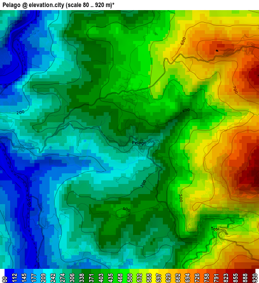
Below is the Elevation map of Pelago, which displays elevation range with different colors. Scale of the first map is from 80 to 920 m (262 to 3018 ft) with average elevation of 387.6 meters (=1272 ft) [note 1]
These maps also provides idea of topography and contour of this city, they are displayed at different zoom levels. More info about maps, scale and edge coordinates you can find below images.
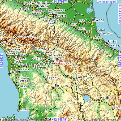
| \ | Map #1 | Topo.Map |
| Scale [m] | 80..920 m | × |
| Scale [ft] | 262..3018 ft | × |
| Average | 387.6 m = 1272 ft | × |
| Width | 7.06 km = 4.4 mi | 225.8 km = 140.3 mi |
| Height | 7.06 km = 4.4 mi | 225.8 km = 140.3 mi |
| ↑Max Latitude | 43.804274° | 44.77937° |
| Latitude at center | 43.77255° | 43.77255° |
| ↓Min Latitude | 43.740809° | 42.74849° |
| ← Min Longitude | 11.457535° | 10.09523° |
| Longitude center | 11.50148° | 11.50148° |
| →Max Longitude | 11.545425° | 12.90773° |
Nearby cities:
Cities around Pelago sort by population:
• Pontassieve elevation 92 m
5.7 km,  272°
272°
• Rufina 113 m
5.8 km,  348°
348°
• Reggello 365 m
10.6 km,  167°
167°
• Sieci 76 m
8.8 km,  281°
281°
• Rignano sull'Arno 135 m
6.9 km,  215°
215°
• San Francesco 97 m
4.3 km, 273°
• Compiobbi 75 m
11.5 km, 276°
• Molino del Piano 104 m
9.2 km,  297°
297°
• Montebonello 120 m
6.5 km, 349°
• Londa 211 m
11.3 km,  26°
26°
• Montemignaio 758 m
10.1 km,  111°
111°
• La Pieve-Molino 782 m
10.3 km, 112°
Multilingual:
 En español:
Pelago elevación 314 m.
 En France:
Pelago élévation 314 m.


Sources and notes:
- [note 1] Map square and city borders are not equal. Map elevation data is calculated only from area inside that square.
- [src 1] Elevation data from geonames database provided with same terms of usage.
- [src 2] The elevation map of Pelago is generated using elevation data from NASA's 3 arcsec (90m) resolution SRTM data.
- [src 3] Base (background) map © OpenStreetMap contributors tiles are generated by Geofabrik and OpenTopoMap.
Copyright & License:
This Pelago Elevation Map is licensed under CC BY-SA. You may reuse any part from this page, if you give a proper credit by linking to this URL:
 More info on terms of use page.