Montemignaio elevation
Montemignaio (Tuscany, Province of Arezzo), Italy elevation is 758 meters and Montemignaio elevation in feet is 2487 ft above sea level [src 1]. Montemignaio is a seat of a third-order administrative division (feature code) with elevation that is 436 meters (1430 ft) bigger than average city elevation in Italy.
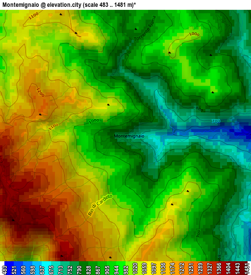
Below is the Elevation map of Montemignaio, which displays elevation range with different colors. Scale of the first map is from 483 to 1481 m (1585 to 4859 ft) with average elevation of 981.5 meters (=3220 ft) [note 1]
These maps also provides idea of topography and contour of this city, they are displayed at different zoom levels. More info about maps, scale and edge coordinates you can find below images.
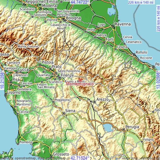
| \ | Map #1 | Topo.Map |
| Scale [m] | 483..1481 m | × |
| Scale [ft] | 1585..4859 ft | × |
| Average | 981.5 m = 3220 ft | × |
| Width | 7.06 km = 4.4 mi | 225.9 km = 140.4 mi |
| Height | 7.06 km = 4.4 mi | 225.9 km = 140.4 mi |
| ↑Max Latitude | 43.771591° | 44.74722° |
| Latitude at center | 43.73985° | 43.73985° |
| ↓Min Latitude | 43.708092° | 42.71524° |
| ← Min Longitude | 11.574885° | 10.21258° |
| Longitude center | 11.61883° | 11.61883° |
| →Max Longitude | 11.662775° | 13.02508° |
Nearby cities:
Cities around Montemignaio sort by population:
• Reggello elevation 365 m
9.8 km,  226°
226°
• Rignano sull'Arno 135 m
13.6 km,  261°
261°
• Castel San Niccolò 377 m
7.3 km,  85°
85°
• Ponte a Poppi 346 m
11.9 km, 94°
• Stia 452 m
9.8 km,  47°
47°
• Pian di Scò 327 m
12.4 km,  208°
208°
• Pratovecchio 423 m
9.9 km,  58°
58°
• Pelago 314 m
10.1 km,  291°
291°
• Strada 376 m
7.3 km, 85°
• Poppi 398 m
12 km,  99°
99°
• Ortignano Raggiolo 425 m
12.4 km,  122°
122°
• La Pieve-Molino 782 m
0.3 km,  157°
157°
Multilingual:
 En español:
Montemignaio elevación 758 m.
 En France:
Montemignaio élévation 758 m.
 Auf Deutsch:
Montemignaio höhe über dem Meeresspiegel ist 758 m.

Sources and notes:
- [note 1] Map square and city borders are not equal. Map elevation data is calculated only from area inside that square.
- [src 1] Elevation data from geonames database provided with same terms of usage.
- [src 2] The elevation map of Montemignaio is generated using elevation data from NASA's 3 arcsec (90m) resolution SRTM data.
- [src 3] Base (background) map © OpenStreetMap contributors tiles are generated by Geofabrik and OpenTopoMap.
Copyright & License:
This Montemignaio Elevation Map is licensed under CC BY-SA. You may reuse any part from this page, if you give a proper credit by linking to this URL:
 More info on terms of use page.