Montebonello elevation
Montebonello (Tuscany, Province of Florence), Italy elevation is 120 meters and Montebonello elevation in feet is 394 ft above sea level [src 1]. Montebonello is a populated place (feature code) with elevation that is 202 meters (663 ft) smaller than average city elevation in Italy.
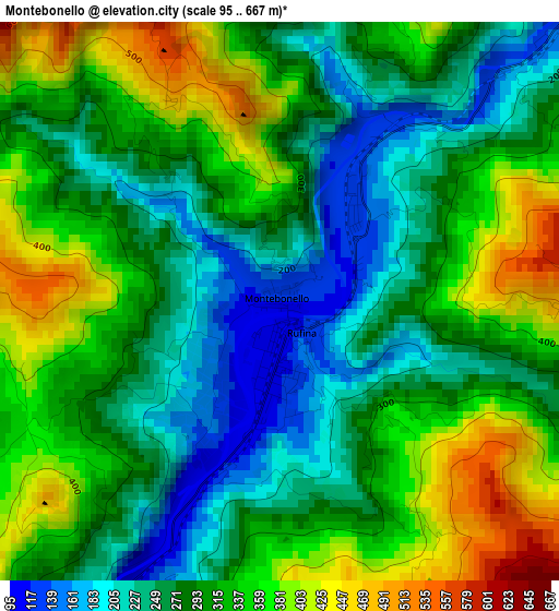
Below is the Elevation map of Montebonello, which displays elevation range with different colors. Scale of the first map is from 95 to 667 m (312 to 2188 ft) with average elevation of 302.7 meters (=993 ft) [note 1]
These maps also provides idea of topography and contour of this city, they are displayed at different zoom levels. More info about maps, scale and edge coordinates you can find below images.
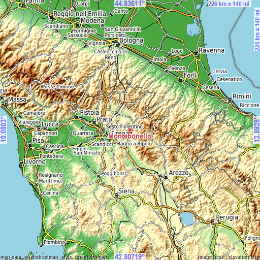
| \ | Map #1 | Topo.Map |
| Scale [m] | 95..667 m | × |
| Scale [ft] | 312..2188 ft | × |
| Average | 302.7 m = 993 ft | × |
| Width | 7.05 km = 4.4 mi | 225.6 km = 140.2 mi |
| Height | 7.05 km = 4.4 mi | 225.6 km = 140.2 mi |
| ↑Max Latitude | 43.861963° | 44.83611° |
| Latitude at center | 43.83027° | 43.83027° |
| ↓Min Latitude | 43.79856° | 42.80719° |
| ← Min Longitude | 11.442605° | 10.0803° |
| Longitude center | 11.48655° | 11.48655° |
| →Max Longitude | 11.530495° | 12.8928° |
Nearby cities:
Cities around Montebonello sort by population:
• Pontassieve elevation 92 m
7.6 km,  215°
215°
• Rufina 113 m
0.7 km,  178°
178°
• Vicchio 186 m
11.7 km,  349°
349°
• Dicomano 163 m
7.5 km,  22°
22°
• Sieci 76 m
8.7 km,  237°
237°
• Rignano sull'Arno 135 m
12.4 km,  192°
192°
• San Francesco 97 m
6.9 km,  206°
206°
• Compiobbi 75 m
11.4 km, 243°
• San Jacopo al Girone 66 m
13.5 km, 240°
• Molino del Piano 104 m
7.3 km,  252°
252°
• Londa 211 m
7.2 km,  59°
59°
• Pelago 314 m
6.5 km,  169°
169°
Multilingual:
 En español:
Montebonello elevación 120 m.
 En France:
Montebonello élévation 120 m.
 Auf Deutsch:
Montebonello höhe über dem Meeresspiegel ist 120 m.

Sources and notes:
- [note 1] Map square and city borders are not equal. Map elevation data is calculated only from area inside that square.
- [src 1] Elevation data from geonames database provided with same terms of usage.
- [src 2] The elevation map of Montebonello is generated using elevation data from NASA's 3 arcsec (90m) resolution SRTM data.
- [src 3] Base (background) map © OpenStreetMap contributors tiles are generated by Geofabrik and OpenTopoMap.
Copyright & License:
This Montebonello Elevation Map is licensed under CC BY-SA. You may reuse any part from this page, if you give a proper credit by linking to this URL:
 More info on terms of use page.