Pico elevation
Pico (Latium, Provincia di Frosinone), Italy elevation is 168 meters and Pico elevation in feet is 551 ft above sea level [src 1]. Pico is a seat of a third-order administrative division (feature code) with elevation that is 154 meters (505 ft) smaller than average city elevation in Italy.
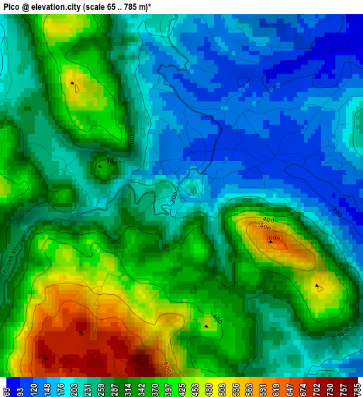
Below is the Elevation map of Pico, which displays elevation range with different colors. Scale of the first map is from 65 to 785 m (213 to 2575 ft) with average elevation of 294.3 meters (=966 ft) [note 1]
These maps also provides idea of topography and contour of this city, they are displayed at different zoom levels. More info about maps, scale and edge coordinates you can find below images.
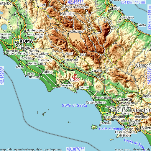
| \ | Map #1 | Topo.Map |
| Scale [m] | 65..785 m | × |
| Scale [ft] | 213..2575 ft | × |
| Average | 294.3 m = 966 ft | × |
| Width | 7.32 km = 4.5 mi | 234.4 km = 145.6 mi |
| Height | 7.32 km = 4.5 mi | 234.4 km = 145.6 mi |
| ↑Max Latitude | 41.48318° | 42.4957° |
| Latitude at center | 41.45025° | 41.45025° |
| ↓Min Latitude | 41.417303° | 40.38767° |
| ← Min Longitude | 13.514995° | 12.15269° |
| Longitude center | 13.55894° | 13.55894° |
| →Max Longitude | 13.602885° | 14.96519° |
Nearby cities:
Cities around Pico sort by population:
• Pontecorvo elevation 96 m
9 km,  84°
84°
• Ceprano 111 m
11.2 km,  340°
340°
• Aquino 110 m
13.1 km,  68°
68°
• Roccasecca Stazione 134 m
12 km,  39°
39°
• Lenola 440 m
9.7 km,  238°
238°
• Vallecorsa 372 m
12.7 km,  266°
266°
• San Giovanni Incarico 158 m
5.5 km,  359°
359°
• Esperia 330 m
12.9 km,  125°
125°
• Coldragone 149 m
12.2 km,  17°
17°
• Pastena 301 m
6 km,  289°
289°
• Campodimele 615 m
7.3 km,  198°
198°
• Falvaterra 296 m
6.7 km,  333°
333°
Multilingual:
 En español:
Pico elevación 168 m.
 En France:
Pico élévation 168 m.


Sources and notes:
- [note 1] Map square and city borders are not equal. Map elevation data is calculated only from area inside that square.
- [src 1] Elevation data from geonames database provided with same terms of usage.
- [src 2] The elevation map of Pico is generated using elevation data from NASA's 3 arcsec (90m) resolution SRTM data.
- [src 3] Base (background) map © OpenStreetMap contributors tiles are generated by Geofabrik and OpenTopoMap.
Copyright & License:
This Pico Elevation Map is licensed under CC BY-SA. You may reuse any part from this page, if you give a proper credit by linking to this URL:
 More info on terms of use page.