Esperia elevation
Esperia (Latium, Provincia di Frosinone), Italy elevation is 330 meters and Esperia elevation in feet is 1083 ft above sea level [src 1]. Esperia is a seat of a third-order administrative division (feature code) with elevation that is 8 meters (26 ft) bigger than average city elevation in Italy.
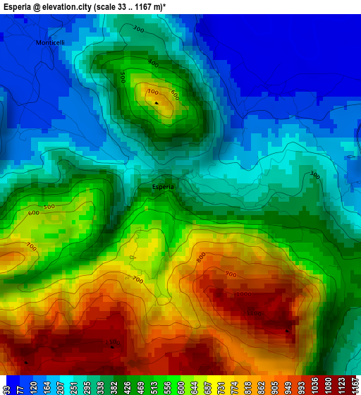
Below is the Elevation map of Esperia, which displays elevation range with different colors. Scale of the first map is from 33 to 1167 m (108 to 3829 ft) with average elevation of 471.9 meters (=1548 ft) [note 1]
These maps also provides idea of topography and contour of this city, they are displayed at different zoom levels. More info about maps, scale and edge coordinates you can find below images.
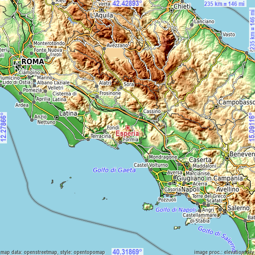
| \ | Map #1 | Topo.Map |
| Scale [m] | 33..1167 m | × |
| Scale [ft] | 108..3829 ft | × |
| Average | 471.9 m = 1548 ft | × |
| Width | 7.33 km = 4.6 mi | 234.6 km = 145.8 mi |
| Height | 7.33 km = 4.6 mi | 234.6 km = 145.8 mi |
| ↑Max Latitude | 41.415334° | 42.42893° |
| Latitude at center | 41.38237° | 41.38237° |
| ↓Min Latitude | 41.349389° | 40.31869° |
| ← Min Longitude | 13.640965° | 12.27866° |
| Longitude center | 13.68491° | 13.68491° |
| →Max Longitude | 13.728855° | 15.09116° |
Nearby cities:
Cities around Esperia sort by population:
• Pontecorvo elevation 96 m
8.6 km,  349°
349°
• Maranola-Trivio 233 m
11.8 km,  203°
203°
• Penitro 40 m
12.1 km,  176°
176°
• San Giorgio a Liri 41 m
6.8 km,  67°
67°
• Coreno Ausonio 309 m
8.6 km,  117°
117°
• Spigno Saturnia Inferiore 53 m
9 km,  151°
151°
• Ausonia 165 m
6.1 km, 116°
• Castelnuovo Parano 322 m
6 km,  93°
93°
• Pignataro Interamna 75 m
10.6 km,  53°
53°
• Vallemaio 293 m
10.5 km,  99°
99°
• Spigno Saturnia Superiore 356 m
7.8 km,  165°
165°
• Casali 315 m
5.8 km, 94°
Multilingual:
 En español:
Esperia elevación 330 m.
 En France:
Esperia élévation 330 m.


Sources and notes:
- [note 1] Map square and city borders are not equal. Map elevation data is calculated only from area inside that square.
- [src 1] Elevation data from geonames database provided with same terms of usage.
- [src 2] The elevation map of Esperia is generated using elevation data from NASA's 3 arcsec (90m) resolution SRTM data.
- [src 3] Base (background) map © OpenStreetMap contributors tiles are generated by Geofabrik and OpenTopoMap.
Copyright & License:
This Esperia Elevation Map is licensed under CC BY-SA. You may reuse any part from this page, if you give a proper credit by linking to this URL:
 More info on terms of use page.