Postua elevation
Postua (Piedmont, Provincia di Vercelli), Italy elevation is 450 meters and Postua elevation in feet is 1476 ft above sea level [src 1]. Postua is a seat of a third-order administrative division (feature code) with elevation that is 128 meters (420 ft) bigger than average city elevation in Italy.
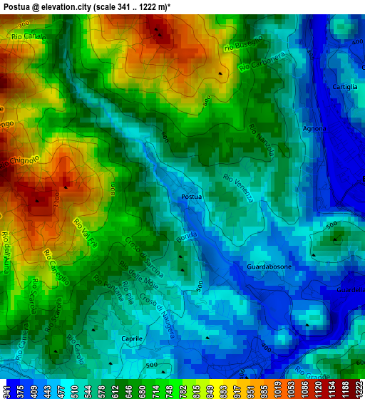
Below is the Elevation map of Postua, which displays elevation range with different colors. Scale of the first map is from 341 to 1222 m (1119 to 4009 ft) with average elevation of 626.3 meters (=2055 ft) [note 1]
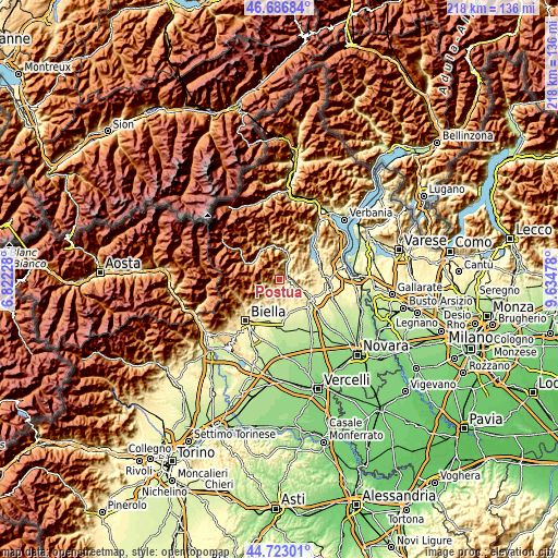
These maps also provides idea of topography and contour of this city, they are displayed at different zoom levels. More info about maps, scale and edge coordinates you can find below images.
| \ | Map #1 | Topo.Map |
| Scale [m] | 341..1222 m | × |
| Scale [ft] | 1119..4009 ft | × |
| Average | 626.3 m = 2055 ft | × |
| Width | 6.82 km = 4.2 mi | 218.4 km = 135.7 mi |
| Height | 6.82 km = 4.2 mi | 218.3 km = 135.6 mi |
| ↑Max Latitude | 45.744226° | 46.68684° |
| Latitude at center | 45.71355° | 45.71355° |
| ↓Min Latitude | 45.682857° | 44.72301° |
| ← Min Longitude | 8.184585° | 6.82228° |
| Longitude center | 8.22853° | 8.22853° |
| →Max Longitude | 8.272475° | 9.63478° |
Nearby cities:
Cities around Postua sort by population:
• Borgosesia elevation 414 m
3.7 km,  77°
77°
• Serravalle Sesia 333 m
7 km,  117°
117°
• Trivero-Prativero-Ponzone 579 m
7.3 km,  215°
215°
• Quarona 403 m
6 km,  30°
30°
• Coggiola 513 m
4.7 km,  229°
229°
• Crevacuore 387 m
3.3 km,  158°
158°
• Pray 422 m
4.5 km,  199°
199°
• Sostegno 403 m
7.5 km,  154°
154°
• Portula 672 m
6.1 km, 225°
• Guardabosone 471 m
2.1 km,  128°
128°
• Ailoche 540 m
1.8 km, 198°
• Frazione Chiesa 551 m
2.5 km,  210°
210°
Multilingual:
 En español:
Postua elevación 450 m.
 En France:
Postua élévation 450 m.


Sources and notes:
- [note 1] Map square and city borders are not equal. Map elevation data is calculated only from area inside that square.
- [src 1] Elevation data from geonames database provided with same terms of usage.
- [src 2] The elevation map of Postua is generated using elevation data from NASA's 3 arcsec (90m) resolution SRTM data.
- [src 3] Base (background) map © OpenStreetMap contributors tiles are generated by Geofabrik and OpenTopoMap.
Copyright & License:
This Postua Elevation Map is licensed under CC BY-SA. You may reuse any part from this page, if you give a proper credit by linking to this URL:
 More info on terms of use page.