Coggiola elevation
Coggiola (Piedmont, Provincia di Biella), Italy elevation is 513 meters and Coggiola elevation in feet is 1683 ft above sea level [src 1]. Coggiola is a seat of a third-order administrative division (feature code) with elevation that is 191 meters (627 ft) bigger than average city elevation in Italy.
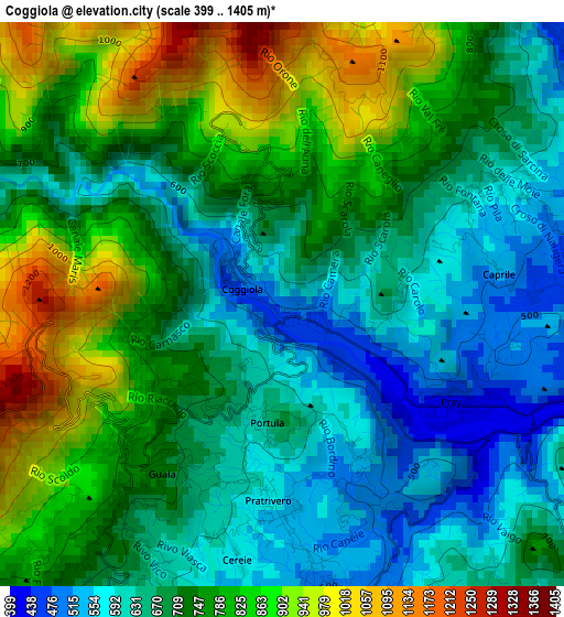
Below is the Elevation map of Coggiola, which displays elevation range with different colors. Scale of the first map is from 399 to 1405 m (1309 to 4610 ft) with average elevation of 728.7 meters (=2391 ft) [note 1]
These maps also provides idea of topography and contour of this city, they are displayed at different zoom levels. More info about maps, scale and edge coordinates you can find below images.
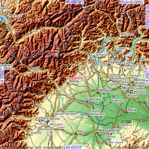
| \ | Map #1 | Topo.Map |
| Scale [m] | 399..1405 m | × |
| Scale [ft] | 1309..4610 ft | × |
| Average | 728.7 m = 2391 ft | × |
| Width | 6.83 km = 4.2 mi | 218.5 km = 135.8 mi |
| Height | 6.83 km = 4.2 mi | 218.5 km = 135.8 mi |
| ↑Max Latitude | 45.717091° | 46.66016° |
| Latitude at center | 45.6864° | 45.6864° |
| ↓Min Latitude | 45.655692° | 44.69539° |
| ← Min Longitude | 8.138575° | 6.77627° |
| Longitude center | 8.18252° | 8.18252° |
| →Max Longitude | 8.226465° | 9.58877° |
Nearby cities:
Cities around Coggiola sort by population:
• Trivero-Prativero-Ponzone elevation 579 m
3 km,  192°
192°
• Mosso 692 m
5.3 km,  220°
220°
• Crevacuore 387 m
4.8 km,  91°
91°
• Pray 422 m
2.4 km,  120°
120°
• Mosso Santa Maria 682 m
5.4 km, 220°
• Soprana 468 m
5.4 km,  166°
166°
• Portula 672 m
1.5 km,  211°
211°
• Postua 450 m
4.7 km,  49°
49°
• Lanvario 490 m
5.3 km, 166°
• Guardabosone 471 m
5.5 km,  71°
71°
• Ailoche 540 m
3.3 km, 66°
• Frazione Chiesa 551 m
2.5 km, 69°
Multilingual:
 En español:
Coggiola elevación 513 m.
 En France:
Coggiola élévation 513 m.
 Auf Deutsch:
Coggiola höhe über dem Meeresspiegel ist 513 m.

Sources and notes:
- [note 1] Map square and city borders are not equal. Map elevation data is calculated only from area inside that square.
- [src 1] Elevation data from geonames database provided with same terms of usage.
- [src 2] The elevation map of Coggiola is generated using elevation data from NASA's 3 arcsec (90m) resolution SRTM data.
- [src 3] Base (background) map © OpenStreetMap contributors tiles are generated by Geofabrik and OpenTopoMap.
Copyright & License:
This Coggiola Elevation Map is licensed under CC BY-SA. You may reuse any part from this page, if you give a proper credit by linking to this URL:
 More info on terms of use page.