Rieti elevation
Rieti (Latium, Provincia di Rieti), Italy elevation is 395 meters and Rieti elevation in feet is 1296 ft above sea level [src 1]. Rieti is a seat of a second-order administrative division (feature code) with elevation that is 73 meters (240 ft) bigger than average city elevation in Italy.
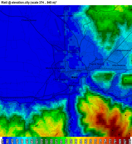
Below is the Elevation map of Rieti, which displays elevation range with different colors. Scale of the first map is from 374 to 845 m (1227 to 2772 ft) with average elevation of 459.6 meters (=1508 ft) [note 1]
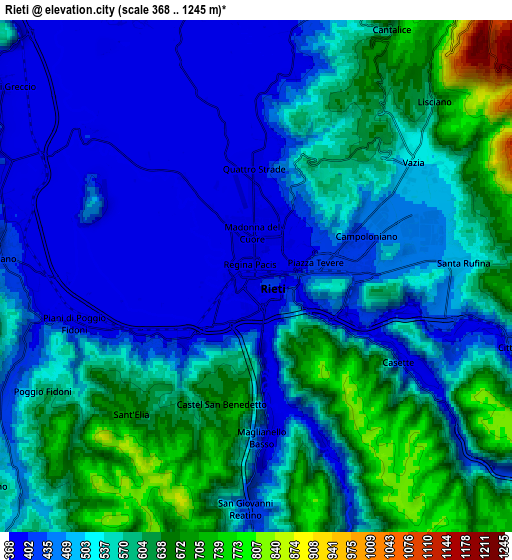
These maps also provides idea of topography and contour of this city, they are displayed at different zoom levels. More info about maps, scale and edge coordinates you can find below images.
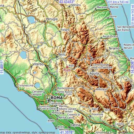
| \ | Map #1 | Map #2 | Topo.Map |
| Scale [m] | 374..845 m | 368..1245 m | × |
| Scale [ft] | 1227..2772 ft | 1207..4085 ft | × |
| Average | 459.6 m = 1508 ft | 525.4 m = 1724 ft | × |
| Width | 7.22 km = 4.5 mi | 14.43 km = 9 mi | 230.9 km = 143.5 mi |
| Height | 7.22 km = 4.5 mi | 14.43 km = 9 mi | 230.9 km = 143.5 mi |
| ↑Max Latitude | 42.437201° | 42.469625° | 43.43453° |
| Latitude at center | 42.40476° | 42.40476° | 42.40476° |
| ↓Min Latitude | 42.372302° | 42.339828° | 41.3578° |
| ← Min Longitude | 12.813405° | 12.769459° | 11.4511° |
| Longitude center | 12.85735° | 12.85735° | 12.85735° |
| →Max Longitude | 12.901295° | 12.945241° | 14.2636° |
Nearby cities:
Cities around Rieti sort by population:
• Santa Rufina elevation 465 m
5 km,  84°
84°
• Cittaducale 504 m
8.3 km,  104°
104°
• Contigliano 413 m
7 km,  275°
275°
• Poggio Bustone 750 m
11.2 km,  11°
11°
• Limiti di Greccio 400 m
9 km,  306°
306°
• Colli sul Velino 460 m
12.1 km,  329°
329°
• Cantalice 728 m
7.7 km,  30°
30°
• Castel Sant'Angelo 443 m
14 km, 95°
• Rivodutri 565 m
12.5 km,  359°
359°
• Belmonte in Sabina 713 m
10.4 km,  164°
164°
• Monte San Giovanni in Sabina 676 m
10.8 km,  216°
216°
• Morro Reatino 769 m
13.2 km,  351°
351°
Multilingual:
 En español:
Rieti elevación 395 m.
 En France:
Rieti élévation 395 m.


Sources and notes:
- [note 1] Map square and city borders are not equal. Map elevation data is calculated only from area inside that square.
- [src 1] Elevation data from geonames database provided with same terms of usage.
- [src 2] The elevation map of Rieti is generated using elevation data from NASA's 3 arcsec (90m) resolution SRTM data.
- [src 3] Base (background) map © OpenStreetMap contributors tiles are generated by Geofabrik and OpenTopoMap.
Copyright & License:
This Rieti Elevation Map is licensed under CC BY-SA. You may reuse any part from this page, if you give a proper credit by linking to this URL:
 More info on terms of use page.