Santa Rufina elevation
Santa Rufina (Latium, Provincia di Rieti), Italy elevation is 465 meters and Santa Rufina elevation in feet is 1526 ft above sea level [src 1]. Santa Rufina is a populated place (feature code) with elevation that is 143 meters (469 ft) bigger than average city elevation in Italy.
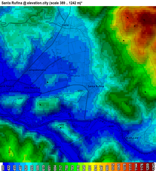
Below is the Elevation map of Santa Rufina, which displays elevation range with different colors. Scale of the first map is from 389 to 1242 m (1276 to 4075 ft) with average elevation of 572.6 meters (=1879 ft) [note 1]
These maps also provides idea of topography and contour of this city, they are displayed at different zoom levels. More info about maps, scale and edge coordinates you can find below images.
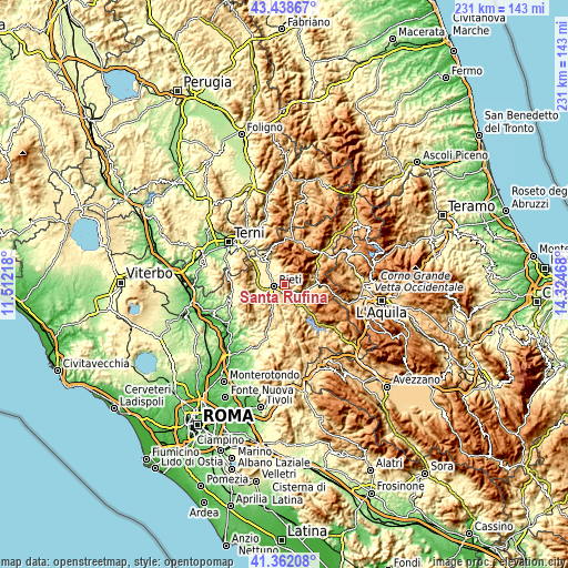
| \ | Map #1 | Topo.Map |
| Scale [m] | 389..1242 m | × |
| Scale [ft] | 1276..4075 ft | × |
| Average | 572.6 m = 1879 ft | × |
| Width | 7.22 km = 4.5 mi | 230.9 km = 143.5 mi |
| Height | 7.22 km = 4.5 mi | 230.9 km = 143.5 mi |
| ↑Max Latitude | 42.441409° | 43.43867° |
| Latitude at center | 42.40897° | 42.40897° |
| ↓Min Latitude | 42.376515° | 41.36208° |
| ← Min Longitude | 12.874485° | 11.51218° |
| Longitude center | 12.91843° | 12.91843° |
| →Max Longitude | 12.962375° | 14.32468° |
Nearby cities:
Cities around Santa Rufina sort by population:
• Rieti elevation 395 m
5 km,  264°
264°
• Antrodoco 477 m
13 km,  87°
87°
• Cittaducale 504 m
3.9 km,  129°
129°
• Contigliano 413 m
12 km,  270°
270°
• Borgo Velino 462 m
11.3 km, 92°
• Poggio Bustone 750 m
10.8 km,  345°
345°
• Cantalice 728 m
6.3 km, 349°
• Castel Sant'Angelo 443 m
9.1 km,  100°
100°
• Concerviano 559 m
11.1 km,  150°
150°
• Rivodutri 565 m
13 km,  336°
336°
• Belmonte in Sabina 713 m
10.7 km,  191°
191°
• Micigliano 905 m
12.1 km,  66°
66°
Multilingual:
 En español:
Santa Rufina elevación 465 m.
 En France:
Santa Rufina élévation 465 m.
 Auf Deutsch:
Santa Rufina höhe über dem Meeresspiegel ist 465 m.

Sources and notes:
- [note 1] Map square and city borders are not equal. Map elevation data is calculated only from area inside that square.
- [src 1] Elevation data from geonames database provided with same terms of usage.
- [src 2] The elevation map of Santa Rufina is generated using elevation data from NASA's 3 arcsec (90m) resolution SRTM data.
- [src 3] Base (background) map © OpenStreetMap contributors tiles are generated by Geofabrik and OpenTopoMap.
Copyright & License:
This Santa Rufina Elevation Map is licensed under CC BY-SA. You may reuse any part from this page, if you give a proper credit by linking to this URL:
 More info on terms of use page.