Roccamonfina elevation
Roccamonfina (Campania, Provincia di Caserta), Italy elevation is 602 meters and Roccamonfina elevation in feet is 1975 ft above sea level [src 1]. Roccamonfina is a seat of a third-order administrative division (feature code) with elevation that is 280 meters (919 ft) bigger than average city elevation in Italy.
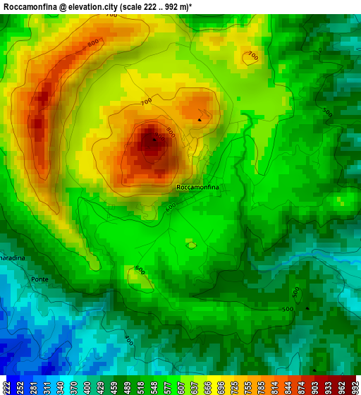
Below is the Elevation map of Roccamonfina, which displays elevation range with different colors. Scale of the first map is from 222 to 992 m (728 to 3255 ft) with average elevation of 564.5 meters (=1852 ft) [note 1]
These maps also provides idea of topography and contour of this city, they are displayed at different zoom levels. More info about maps, scale and edge coordinates you can find below images.
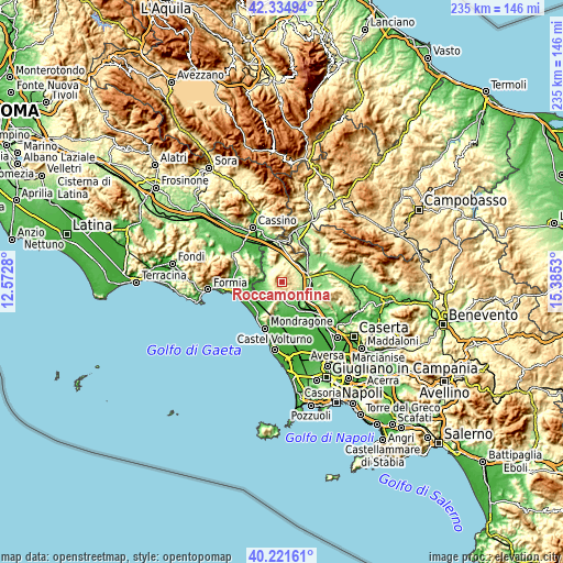
| \ | Map #1 | Topo.Map |
| Scale [m] | 222..992 m | × |
| Scale [ft] | 728..3255 ft | × |
| Average | 564.5 m = 1852 ft | × |
| Width | 7.34 km = 4.6 mi | 235 km = 146 mi |
| Height | 7.34 km = 4.6 mi | 235 km = 146 mi |
| ↑Max Latitude | 41.319843° | 42.33494° |
| Latitude at center | 41.28683° | 41.28683° |
| ↓Min Latitude | 41.2538° | 40.22161° |
| ← Min Longitude | 13.935105° | 12.5728° |
| Longitude center | 13.97905° | 13.97905° |
| →Max Longitude | 14.022995° | 15.3853° |
Nearby cities:
Cities around Roccamonfina sort by population:
• Sessa Aurunca elevation 201 m
6.7 km,  218°
218°
• Teano 208 m
8.3 km,  118°
118°
• Marzano Appio 296 m
6.5 km,  58°
58°
• Lauro 100 m
7.8 km,  250°
250°
• Casale 178 m
7.7 km,  165°
165°
• Cascano 217 m
6.1 km,  187°
187°
• Grottola 315 m
6.2 km, 57°
• San Clemente 367 m
6.2 km,  342°
342°
• Santa Lucia 223 m
8.6 km,  77°
77°
• Tora 312 m
7 km,  32°
32°
• Conca della Campania 452 m
5.1 km,  11°
11°
• Galluccio 296 m
7.6 km, 343°
Multilingual:
 En español:
Roccamonfina elevación 602 m.
 En France:
Roccamonfina élévation 602 m.
 Auf Deutsch:
Roccamonfina höhe über dem Meeresspiegel ist 602 m.

Sources and notes:
- [note 1] Map square and city borders are not equal. Map elevation data is calculated only from area inside that square.
- [src 1] Elevation data from geonames database provided with same terms of usage.
- [src 2] The elevation map of Roccamonfina is generated using elevation data from NASA's 3 arcsec (90m) resolution SRTM data.
- [src 3] Base (background) map © OpenStreetMap contributors tiles are generated by Geofabrik and OpenTopoMap.
Copyright & License:
This Roccamonfina Elevation Map is licensed under CC BY-SA. You may reuse any part from this page, if you give a proper credit by linking to this URL:
 More info on terms of use page.