San Benedetto del Tronto elevation
San Benedetto del Tronto (The Marches, Provincia di Ascoli Piceno), Italy elevation is 7 meters and San Benedetto del Tronto elevation in feet is 23 ft above sea level [src 1]. San Benedetto del Tronto is a seat of a third-order administrative division (feature code) with elevation that is 315 meters (1033 ft) smaller than average city elevation in Italy.
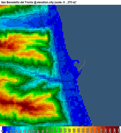
Below is the Elevation map of San Benedetto del Tronto, which displays elevation range with different colors. Scale of the first map is from -5 to 275 m (-16 to 902 ft) with average elevation of 88.9 meters (=292 ft) [note 1]
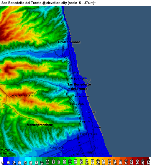
These maps also provides idea of topography and contour of this city, they are displayed at different zoom levels. More info about maps, scale and edge coordinates you can find below images.
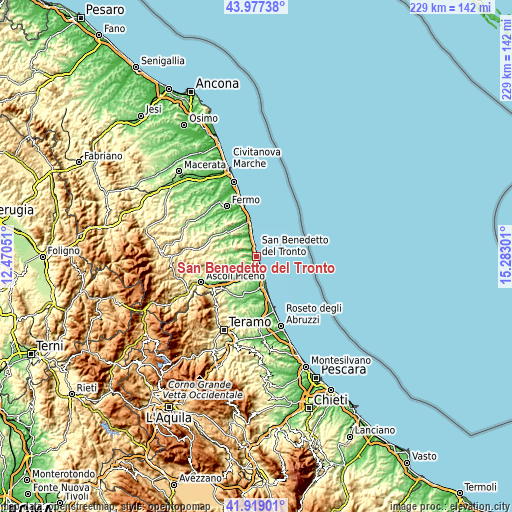
| \ | Map #1 | Map #2 | Topo.Map |
| Scale [m] | -5..275 m | -5..374 m | × |
| Scale [ft] | -16..902 ft | -16..1227 ft | × |
| Average | 88.9 m = 292 ft | 120.9 m = 397 ft | × |
| Width | 7.15 km = 4.4 mi | 14.3 km = 8.9 mi | 228.9 km = 142.2 mi |
| Height | 7.15 km = 4.4 mi | 14.3 km = 8.9 mi | 228.9 km = 142.2 mi |
| ↑Max Latitude | 42.988954° | 43.021091° | 43.97738° |
| Latitude at center | 42.9568° | 42.9568° | 42.9568° |
| ↓Min Latitude | 42.924629° | 42.892442° | 41.91901° |
| ← Min Longitude | 13.832815° | 13.788869° | 12.47051° |
| Longitude center | 13.87676° | 13.87676° | 13.87676° |
| →Max Longitude | 13.920705° | 13.964651° | 15.28301° |
Nearby cities:
Cities around San Benedetto del Tronto sort by population:
• Grottammare elevation 7 m
2.9 km,  345°
345°
• Martinsicuro 0 m
9 km,  160°
160°
• Centobuchi 13 m
7.2 km,  198°
198°
• Cupra Marittima 6 m
7 km, 349°
• Stella 34 m
9.5 km,  215°
215°
• Acquaviva Picena 292 m
4.8 km,  247°
247°
• Ripatransone 487 m
10.5 km,  297°
297°
• Monteprandone 218 m
5.1 km, 217°
• Colonnella 249 m
9.4 km,  183°
183°
• Spinetoli 190 m
11.8 km,  230°
230°
• Monsampolo del Tronto 174 m
9.5 km, 225°
• Massignano 233 m
12.2 km,  328°
328°
Multilingual:
 En español:
San Benedetto del Tronto elevación 7 m.
 En France:
San Benedetto del Tronto élévation 7 m.
 Auf Deutsch:
San Benedetto del Tronto höhe über dem Meeresspiegel ist 7 m.
 На русском:
Сан-Бенедетто-дель-Тронто высота над уровнем моря 7 м
Sources and notes:
- [note 1] Map square and city borders are not equal. Map elevation data is calculated only from area inside that square.
- [src 1] Elevation data from geonames database provided with same terms of usage.
- [src 2] The elevation map of San Benedetto del Tronto is generated using elevation data from NASA's 3 arcsec (90m) resolution SRTM data.
- [src 3] Base (background) map © OpenStreetMap contributors tiles are generated by Geofabrik and OpenTopoMap.
Copyright & License:
This San Benedetto del Tronto Elevation Map is licensed under CC BY-SA. You may reuse any part from this page, if you give a proper credit by linking to this URL:
 More info on terms of use page.