Massignano elevation
Massignano (The Marches, Provincia di Ascoli Piceno), Italy elevation is 233 meters and Massignano elevation in feet is 764 ft above sea level [src 1]. Massignano is a seat of a third-order administrative division (feature code) with elevation that is 89 meters (292 ft) smaller than average city elevation in Italy.
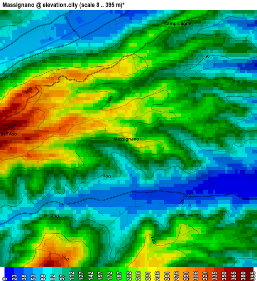
Below is the Elevation map of Massignano, which displays elevation range with different colors. Scale of the first map is from 8 to 395 m (26 to 1296 ft) with average elevation of 142.9 meters (=469 ft) [note 1]
These maps also provides idea of topography and contour of this city, they are displayed at different zoom levels. More info about maps, scale and edge coordinates you can find below images.
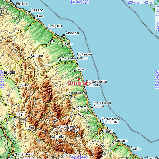
| \ | Map #1 | Topo.Map |
| Scale [m] | 8..395 m | × |
| Scale [ft] | 26..1296 ft | × |
| Average | 142.9 m = 469 ft | × |
| Width | 7.14 km = 4.4 mi | 228.5 km = 142 mi |
| Height | 7.14 km = 4.4 mi | 228.5 km = 142 mi |
| ↑Max Latitude | 43.082725° | 44.06962° |
| Latitude at center | 43.05062° | 43.05062° |
| ↓Min Latitude | 43.018499° | 42.0144° |
| ← Min Longitude | 13.754035° | 12.39173° |
| Longitude center | 13.79798° | 13.79798° |
| →Max Longitude | 13.841925° | 15.20423° |
Nearby cities:
Cities around Massignano sort by population:
• Grottammare elevation 7 m
9.5 km,  143°
143°
• Cupra Marittima 6 m
6.3 km,  124°
124°
• Marina di Altidona 15 m
6.8 km,  25°
25°
• Pedaso 6 m
6.4 km, 33°
• Ripatransone 487 m
6.3 km,  207°
207°
• Montefiore dell'Aso 386 m
3.5 km,  273°
273°
• Campofilone 174 m
3.9 km, 29°
• Monterubbiano 440 m
7.5 km,  301°
301°
• Carassai 321 m
9.2 km,  257°
257°
• Lapedona 240 m
6.9 km,  341°
341°
• Altidona 205 m
6.4 km,  358°
358°
• Moresco 398 m
6.8 km,  306°
306°
Multilingual:
 En español:
Massignano elevación 233 m.
 En France:
Massignano élévation 233 m.
 Auf Deutsch:
Massignano höhe über dem Meeresspiegel ist 233 m.

Sources and notes:
- [note 1] Map square and city borders are not equal. Map elevation data is calculated only from area inside that square.
- [src 1] Elevation data from geonames database provided with same terms of usage.
- [src 2] The elevation map of Massignano is generated using elevation data from NASA's 3 arcsec (90m) resolution SRTM data.
- [src 3] Base (background) map © OpenStreetMap contributors tiles are generated by Geofabrik and OpenTopoMap.
Copyright & License:
This Massignano Elevation Map is licensed under CC BY-SA. You may reuse any part from this page, if you give a proper credit by linking to this URL:
 More info on terms of use page.