Carassai elevation
Carassai (The Marches, Provincia di Ascoli Piceno), Italy elevation is 321 meters and Carassai elevation in feet is 1053 ft above sea level [src 1]. Carassai is a seat of a third-order administrative division (feature code) with elevation that is 1 meters (3 ft) smaller than average city elevation in Italy.
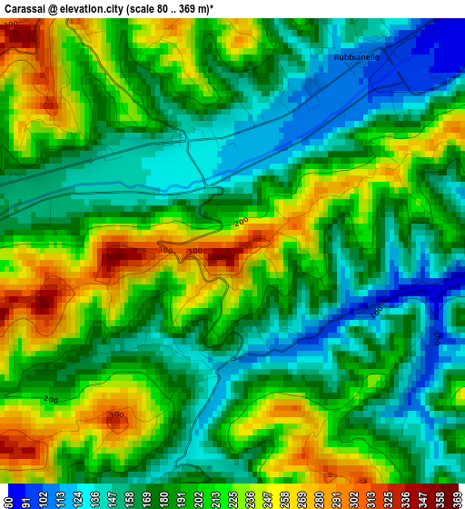
Below is the Elevation map of Carassai, which displays elevation range with different colors. Scale of the first map is from 80 to 369 m (262 to 1211 ft) with average elevation of 192 meters (=630 ft) [note 1]
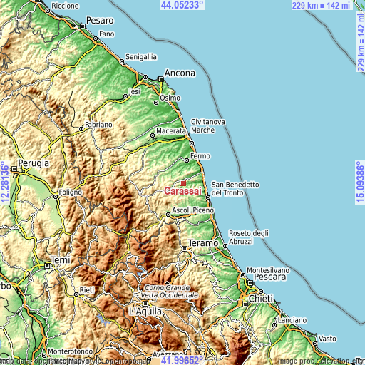
These maps also provides idea of topography and contour of this city, they are displayed at different zoom levels. More info about maps, scale and edge coordinates you can find below images.
| \ | Map #1 | Topo.Map |
| Scale [m] | 80..369 m | × |
| Scale [ft] | 262..1211 ft | × |
| Average | 192 m = 630 ft | × |
| Width | 7.14 km = 4.4 mi | 228.6 km = 142 mi |
| Height | 7.14 km = 4.4 mi | 228.6 km = 142 mi |
| ↑Max Latitude | 43.065144° | 44.05233° |
| Latitude at center | 43.03303° | 43.03303° |
| ↓Min Latitude | 43.000899° | 41.99652° |
| ← Min Longitude | 13.643665° | 12.28136° |
| Longitude center | 13.68761° | 13.68761° |
| →Max Longitude | 13.731555° | 15.09386° |
Nearby cities:
Cities around Carassai sort by population:
• Ripatransone elevation 487 m
7.1 km,  121°
121°
• Montefiore dell'Aso 386 m
5.9 km,  68°
68°
• Petritoli 304 m
4.4 km,  333°
333°
• Montalto delle Marche 505 m
8.1 km,  233°
233°
• Monterubbiano 440 m
6.4 km,  23°
23°
• Monte Vidon Combatte 364 m
4.9 km,  291°
291°
• Monte Rinaldo 457 m
8.6 km,  266°
266°
• Ponzano di Fermo 231 m
8.2 km,  343°
343°
• Cossignano 359 m
5.5 km,  177°
177°
• Moresco 398 m
6.9 km,  30°
30°
• Ortezzano 306 m
6.7 km, 267°
• Monte Giberto 300 m
7.9 km,  324°
324°
Multilingual:
 En español:
Carassai elevación 321 m.
 En France:
Carassai élévation 321 m.
 Auf Deutsch:
Carassai höhe über dem Meeresspiegel ist 321 m.

Sources and notes:
- [note 1] Map square and city borders are not equal. Map elevation data is calculated only from area inside that square.
- [src 1] Elevation data from geonames database provided with same terms of usage.
- [src 2] The elevation map of Carassai is generated using elevation data from NASA's 3 arcsec (90m) resolution SRTM data.
- [src 3] Base (background) map © OpenStreetMap contributors tiles are generated by Geofabrik and OpenTopoMap.
Copyright & License:
This Carassai Elevation Map is licensed under CC BY-SA. You may reuse any part from this page, if you give a proper credit by linking to this URL:
 More info on terms of use page.