Centobuchi elevation
Centobuchi (The Marches, Provincia di Ascoli Piceno), Italy elevation is 13 meters and Centobuchi elevation in feet is 43 ft above sea level [src 1]. Centobuchi is a populated place (feature code) with elevation that is 309 meters (1014 ft) smaller than average city elevation in Italy.
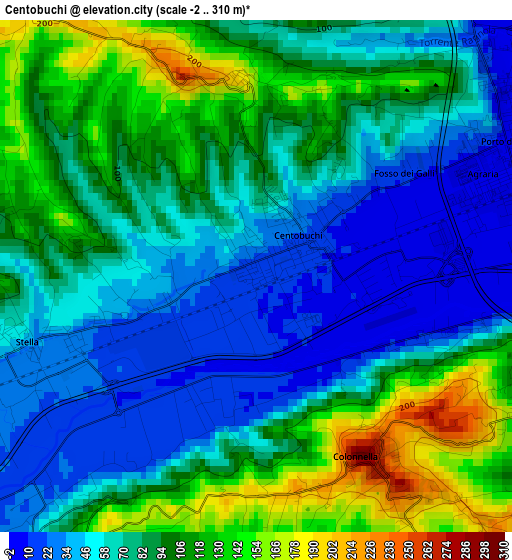
Below is the Elevation map of Centobuchi, which displays elevation range with different colors. Scale of the first map is from -2 to 310 m (-7 to 1017 ft) with average elevation of 80.1 meters (=263 ft) [note 1]
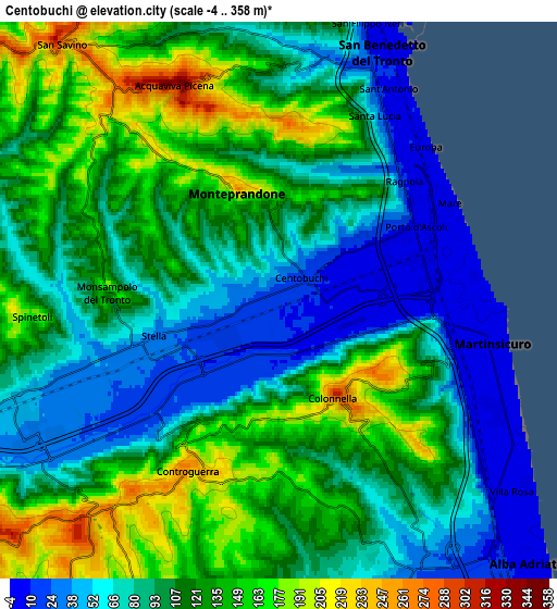
These maps also provides idea of topography and contour of this city, they are displayed at different zoom levels. More info about maps, scale and edge coordinates you can find below images.
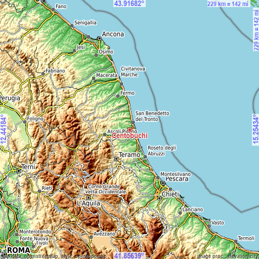
| \ | Map #1 | Map #2 | Topo.Map |
| Scale [m] | -2..310 m | -4..358 m | × |
| Scale [ft] | -7..1017 ft | -13..1175 ft | × |
| Average | 80.1 m = 263 ft | 104.9 m = 344 ft | × |
| Width | 7.16 km = 4.4 mi | 14.32 km = 8.9 mi | 229.1 km = 142.4 mi |
| Height | 7.16 km = 4.4 mi | 14.32 km = 8.9 mi | 229.1 km = 142.4 mi |
| ↑Max Latitude | 42.927396° | 42.959565° | 43.91682° |
| Latitude at center | 42.89521° | 42.89521° | 42.89521° |
| ↓Min Latitude | 42.863007° | 42.830788° | 41.85639° |
| ← Min Longitude | 13.804145° | 13.760199° | 12.44184° |
| Longitude center | 13.84809° | 13.84809° | 13.84809° |
| →Max Longitude | 13.892035° | 13.935981° | 15.25434° |
Nearby cities:
Cities around Centobuchi sort by population:
• San Benedetto del Tronto elevation 7 m
7.2 km,  18°
18°
• Martinsicuro 0 m
5.6 km,  107°
107°
• Pagliare 42 m
7.1 km,  245°
245°
• Villa Rosa 5 m
7.7 km,  130°
130°
• Stella 34 m
3.3 km, 253°
• Corropoli 133 m
7.6 km,  188°
188°
• Acquaviva Picena 292 m
5.4 km,  337°
337°
• Monteprandone 218 m
2.9 km,  345°
345°
• Colonnella 249 m
3.1 km,  145°
145°
• Controguerra 253 m
5.2 km,  208°
208°
• Spinetoli 190 m
6.8 km,  264°
264°
• Monsampolo del Tronto 174 m
4.5 km,  273°
273°
Multilingual:
 En español:
Centobuchi elevación 13 m.
 En France:
Centobuchi élévation 13 m.
 Auf Deutsch:
Centobuchi höhe über dem Meeresspiegel ist 13 m.

Sources and notes:
- [note 1] Map square and city borders are not equal. Map elevation data is calculated only from area inside that square.
- [src 1] Elevation data from geonames database provided with same terms of usage.
- [src 2] The elevation map of Centobuchi is generated using elevation data from NASA's 3 arcsec (90m) resolution SRTM data.
- [src 3] Base (background) map © OpenStreetMap contributors tiles are generated by Geofabrik and OpenTopoMap.
Copyright & License:
This Centobuchi Elevation Map is licensed under CC BY-SA. You may reuse any part from this page, if you give a proper credit by linking to this URL:
 More info on terms of use page.