San Giovanni Lupatoto elevation
San Giovanni Lupatoto (Veneto, Provincia di Verona), Italy elevation is 44 meters and San Giovanni Lupatoto elevation in feet is 144 ft above sea level [src 1]. San Giovanni Lupatoto is a seat of a third-order administrative division (feature code) with elevation that is 278 meters (912 ft) smaller than average city elevation in Italy.
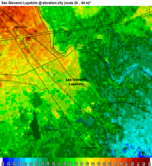
Below is the Elevation map of San Giovanni Lupatoto, which displays elevation range with different colors. Scale of the first map is from 20 to 64 m (66 to 210 ft) with average elevation of 39.1 meters (=128 ft) [note 1]
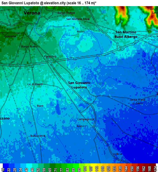
These maps also provides idea of topography and contour of this city, they are displayed at different zoom levels. More info about maps, scale and edge coordinates you can find below images.
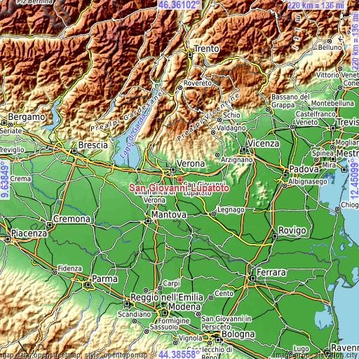
| \ | Map #1 | Map #2 | Topo.Map |
| Scale [m] | 20..64 m | 16..174 m | × |
| Scale [ft] | 66..210 ft | 52..571 ft | × |
| Average | 39.1 m = 128 ft | 41.2 m = 135 ft | × |
| Width | 6.86 km = 4.3 mi | 13.73 km = 8.5 mi | 219.6 km = 136.5 mi |
| Height | 6.86 km = 4.3 mi | 13.73 km = 8.5 mi | 219.6 km = 136.5 mi |
| ↑Max Latitude | 45.412788° | 45.443629° | 46.36102° |
| Latitude at center | 45.38193° | 45.38193° | 45.38193° |
| ↓Min Latitude | 45.351055° | 45.320164° | 44.38558° |
| ← Min Longitude | 11.000795° | 10.956849° | 9.63849° |
| Longitude center | 11.04474° | 11.04474° | 11.04474° |
| →Max Longitude | 11.088685° | 11.132631° | 12.45099° |
Nearby cities:
Cities around San Giovanni Lupatoto sort by population:
• Verona elevation 62 m
7.1 km,  318°
318°
• Zevio 29 m
6.7 km,  99°
99°
• San Martino Buon Albergo 46 m
5.9 km,  42°
42°
• Beccacivetta-Azzano 48 m
6.6 km,  262°
262°
• Montorio 55 m
8.6 km,  11°
11°
• Buttapietra 36 m
5.8 km,  218°
218°
• Vago 43 m
7.9 km,  57°
57°
• Raldon 35 m
3.7 km,  188°
188°
• Vallese 31 m
6.8 km,  151°
151°
• Campagnola 41 m
2.7 km,  171°
171°
• Marchesino-Bovo 43 m
3.9 km,  244°
244°
• Monticelli-Fontana 53 m
9 km,  53°
53°
Multilingual:
 En español:
San Giovanni Lupatoto elevación 44 m.
 En France:
San Giovanni Lupatoto élévation 44 m.
 Auf Deutsch:
San Giovanni Lupatoto höhe über dem Meeresspiegel ist 44 m.
 На русском:
San Giovanni Lupatoto высота над уровнем моря 44 м
Sources and notes:
- [note 1] Map square and city borders are not equal. Map elevation data is calculated only from area inside that square.
- [src 1] Elevation data from geonames database provided with same terms of usage.
- [src 2] The elevation map of San Giovanni Lupatoto is generated using elevation data from NASA's 3 arcsec (90m) resolution SRTM data.
- [src 3] Base (background) map © OpenStreetMap contributors tiles are generated by Geofabrik and OpenTopoMap.
Copyright & License:
This San Giovanni Lupatoto Elevation Map is licensed under CC BY-SA. You may reuse any part from this page, if you give a proper credit by linking to this URL:
 More info on terms of use page.