Vago elevation
Vago (Veneto, Provincia di Verona), Italy elevation is 43 meters and Vago elevation in feet is 141 ft above sea level [src 1]. Vago is a populated place (feature code) with elevation that is 279 meters (915 ft) smaller than average city elevation in Italy.
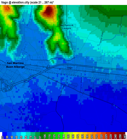
Below is the Elevation map of Vago, which displays elevation range with different colors. Scale of the first map is from 21 to 267 m (69 to 876 ft) with average elevation of 56 meters (=184 ft) [note 1]
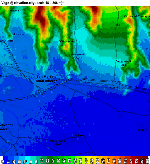
These maps also provides idea of topography and contour of this city, they are displayed at different zoom levels. More info about maps, scale and edge coordinates you can find below images.
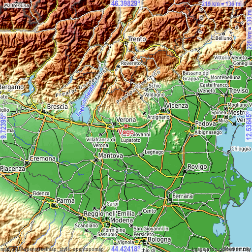
| \ | Map #1 | Map #2 | Topo.Map |
| Scale [m] | 21..267 m | 18..366 m | × |
| Scale [ft] | 69..876 ft | 59..1201 ft | × |
| Average | 56 m = 184 ft | 73.6 m = 241 ft | × |
| Width | 6.86 km = 4.3 mi | 13.72 km = 8.5 mi | 219.5 km = 136.4 mi |
| Height | 6.86 km = 4.3 mi | 13.72 km = 8.5 mi | 219.5 km = 136.4 mi |
| ↑Max Latitude | 45.450697° | 45.481517° | 46.39829° |
| Latitude at center | 45.41986° | 45.41986° | 45.41986° |
| ↓Min Latitude | 45.389006° | 45.358135° | 44.42418° |
| ← Min Longitude | 11.086255° | 11.042309° | 9.72395° |
| Longitude center | 11.1302° | 11.1302° | 11.1302° |
| →Max Longitude | 11.174145° | 11.218091° | 12.53645° |
Nearby cities:
Cities around Vago sort by population:
• Zevio elevation 29 m
5.3 km,  180°
180°
• San Martino Buon Albergo 46 m
2.7 km,  272°
272°
• Lavagno 60 m
2.1 km,  8°
8°
• Caldiero 46 m
3.7 km,  99°
99°
• Montorio 55 m
6.6 km,  310°
310°
• Strà-Montanara-Pieve 54 m
2.2 km,  78°
78°
• Illasi 163 m
6.6 km,  37°
37°
• San Pietro 70 m
2.5 km,  359°
359°
• Colognola ai Colli 79 m
4.5 km,  69°
69°
• Monticelli-Fontana 53 m
1.2 km,  26°
26°
• Caldierino-Rota 44 m
2.1 km, 101°
• Mezzane di Sotto 121 m
6.9 km, 358°
Multilingual:
 En español:
Vago elevación 43 m.
 En France:
Vago élévation 43 m.


Sources and notes:
- [note 1] Map square and city borders are not equal. Map elevation data is calculated only from area inside that square.
- [src 1] Elevation data from geonames database provided with same terms of usage.
- [src 2] The elevation map of Vago is generated using elevation data from NASA's 3 arcsec (90m) resolution SRTM data.
- [src 3] Base (background) map © OpenStreetMap contributors tiles are generated by Geofabrik and OpenTopoMap.
Copyright & License:
This Vago Elevation Map is licensed under CC BY-SA. You may reuse any part from this page, if you give a proper credit by linking to this URL:
 More info on terms of use page.