Sant'Agata de'Goti elevation
Sant'Agata de'Goti (Campania, Provincia di Benevento), Italy elevation is 165 meters and Sant'Agata de'Goti elevation in feet is 541 ft above sea level [src 1]. Sant'Agata de'Goti is a seat of a third-order administrative division (feature code) with elevation that is 157 meters (515 ft) smaller than average city elevation in Italy.
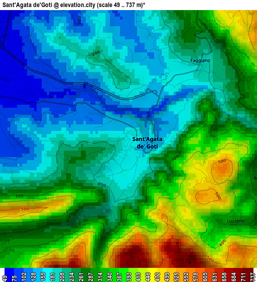
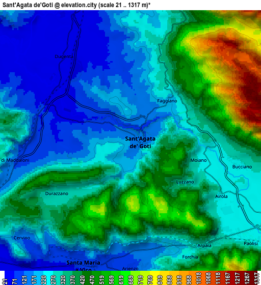
Below is the Elevation map of Sant'Agata de'Goti, which displays elevation range with different colors. Scale of the first map is from 49 to 737 m (161 to 2418 ft) with average elevation of 269.1 meters (=883 ft) [note 1]
These maps also provides idea of topography and contour of this city, they are displayed at different zoom levels. More info about maps, scale and edge coordinates you can find below images.
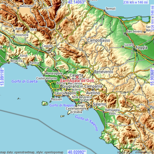
| \ | Map #1 | Map #2 | Topo.Map |
| Scale [m] | 49..737 m | 21..1317 m | × |
| Scale [ft] | 161..2418 ft | 69..4321 ft | × |
| Average | 269.1 m = 883 ft | 323.5 m = 1061 ft | × |
| Width | 7.37 km = 4.6 mi | 14.73 km = 9.2 mi | 235.7 km = 146.5 mi |
| Height | 7.37 km = 4.6 mi | 14.73 km = 9.2 mi | 235.7 km = 146.5 mi |
| ↑Max Latitude | 41.122433° | 41.155529° | 42.14063° |
| Latitude at center | 41.08932° | 41.08932° | 41.08932° |
| ↓Min Latitude | 41.056191° | 41.023045° | 40.02092° |
| ← Min Longitude | 14.453485° | 14.409539° | 13.09118° |
| Longitude center | 14.49743° | 14.49743° | 14.49743° |
| →Max Longitude | 14.541375° | 14.585321° | 15.90368° |
Nearby cities:
Cities around Sant'Agata de'Goti sort by population:
• Santa Maria A Vico elevation 75 m
7.5 km,  201°
201°
• Airola 262 m
6.2 km,  123°
123°
• Arienzo 110 m
6.9 km,  179°
179°
• Moiano 267 m
4.1 km,  105°
105°
• Frasso Telesino 361 m
7.9 km,  18°
18°
• Valle di Maddaloni 129 m
6.8 km,  260°
260°
• Arpaia 307 m
7.4 km,  142°
142°
• Durazzano 288 m
5 km,  233°
233°
• Bucciano 261 m
6.1 km,  102°
102°
• Dugenta 57 m
6.2 km,  323°
323°
• Luzzano 298 m
4 km,  125°
125°
• Forchia 258 m
7.2 km,  153°
153°
Multilingual:
 En español:
Sant'Agata de'Goti elevación 165 m.
 En France:
Sant'Agata de'Goti élévation 165 m.
 Auf Deutsch:
Sant'Agata de'Goti höhe über dem Meeresspiegel ist 165 m.
 На русском:
Sant'Agata de'Goti высота над уровнем моря 165 м
Sources and notes:
- [note 1] Map square and city borders are not equal. Map elevation data is calculated only from area inside that square.
- [src 1] Elevation data from geonames database provided with same terms of usage.
- [src 2] The elevation map of Sant'Agata de'Goti is generated using elevation data from NASA's 3 arcsec (90m) resolution SRTM data.
- [src 3] Base (background) map © OpenStreetMap contributors tiles are generated by Geofabrik and OpenTopoMap.
Copyright & License:
This Sant'Agata de'Goti Elevation Map is licensed under CC BY-SA. You may reuse any part from this page, if you give a proper credit by linking to this URL:
 More info on terms of use page.