Dugenta elevation
Dugenta (Campania, Provincia di Benevento), Italy elevation is 57 meters and Dugenta elevation in feet is 187 ft above sea level [src 1]. Dugenta is a seat of a third-order administrative division (feature code) with elevation that is 265 meters (869 ft) smaller than average city elevation in Italy.
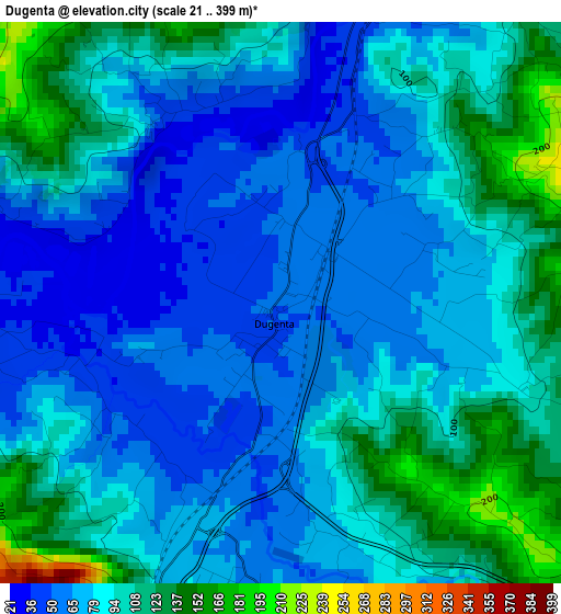
Below is the Elevation map of Dugenta, which displays elevation range with different colors. Scale of the first map is from 21 to 399 m (69 to 1309 ft) with average elevation of 85.6 meters (=281 ft) [note 1]
These maps also provides idea of topography and contour of this city, they are displayed at different zoom levels. More info about maps, scale and edge coordinates you can find below images.
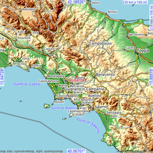
| \ | Map #1 | Topo.Map |
| Scale [m] | 21..399 m | × |
| Scale [ft] | 69..1309 ft | × |
| Average | 85.6 m = 281 ft | × |
| Width | 7.36 km = 4.6 mi | 235.5 km = 146.3 mi |
| Height | 7.36 km = 4.6 mi | 235.5 km = 146.3 mi |
| ↑Max Latitude | 41.16777° | 42.18526° |
| Latitude at center | 41.13468° | 41.13468° |
| ↓Min Latitude | 41.101574° | 40.06701° |
| ← Min Longitude | 14.409585° | 13.04728° |
| Longitude center | 14.45353° | 14.45353° |
| →Max Longitude | 14.497475° | 15.85978° |
Nearby cities:
Cities around Dugenta sort by population:
• Sant'Agata de'Goti elevation 165 m
6.2 km,  143°
143°
• Castel Morrone 230 m
8.4 km,  259°
259°
• Annunziata 246 m
7.6 km, 258°
• Limatola 49 m
5 km,  276°
276°
• Amorosi 56 m
7.6 km,  7°
7°
• Frasso Telesino 361 m
6.7 km,  68°
68°
• Valle di Maddaloni 129 m
6.8 km,  205°
205°
• Durazzano 288 m
8 km,  182°
182°
• Casola 340 m
7.5 km,  233°
233°
• Melizzano 177 m
5.3 km,  55°
55°
• Castel Campagnano 45 m
5.3 km,  359°
359°
• Ruviano 70 m
9.2 km,  336°
336°
Multilingual:
 En español:
Dugenta elevación 57 m.
 En France:
Dugenta élévation 57 m.


Sources and notes:
- [note 1] Map square and city borders are not equal. Map elevation data is calculated only from area inside that square.
- [src 1] Elevation data from geonames database provided with same terms of usage.
- [src 2] The elevation map of Dugenta is generated using elevation data from NASA's 3 arcsec (90m) resolution SRTM data.
- [src 3] Base (background) map © OpenStreetMap contributors tiles are generated by Geofabrik and OpenTopoMap.
Copyright & License:
This Dugenta Elevation Map is licensed under CC BY-SA. You may reuse any part from this page, if you give a proper credit by linking to this URL:
 More info on terms of use page.