Sonico elevation
Sonico (Lombardy, Provincia di Brescia), Italy elevation is 641 meters and Sonico elevation in feet is 2103 ft above sea level [src 1]. Sonico is a seat of a third-order administrative division (feature code) with elevation that is 319 meters (1047 ft) bigger than average city elevation in Italy.
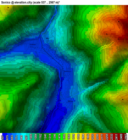
Below is the Elevation map of Sonico, which displays elevation range with different colors. Scale of the first map is from 537 to 2567 m (1762 to 8422 ft) with average elevation of 1180.6 meters (=3873 ft) [note 1]
These maps also provides idea of topography and contour of this city, they are displayed at different zoom levels. More info about maps, scale and edge coordinates you can find below images.
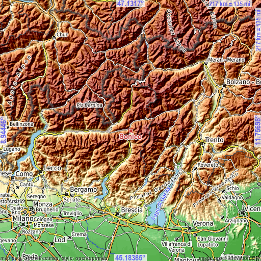
| \ | Map #1 | Topo.Map |
| Scale [m] | 537..2567 m | × |
| Scale [ft] | 1762..8422 ft | × |
| Average | 1180.6 m = 3873 ft | × |
| Width | 6.77 km = 4.2 mi | 216.6 km = 134.6 mi |
| Height | 6.77 km = 4.2 mi | 216.6 km = 134.6 mi |
| ↑Max Latitude | 46.196827° | 47.1317° |
| Latitude at center | 46.1664° | 46.1664° |
| ↓Min Latitude | 46.135957° | 45.18385° |
| ← Min Longitude | 10.306765° | 8.94446° |
| Longitude center | 10.35071° | 10.35071° |
| →Max Longitude | 10.394655° | 11.75696° |
Nearby cities:
Cities around Sonico sort by population:
• Edolo elevation 672 m
1.9 km,  313°
313°
• Malonno 525 m
5.6 km,  206°
206°
• Vezza d'Oglio 1035 m
8.8 km,  24°
24°
• Cedegolo 475 m
10.3 km,  179°
179°
• Cevo 1072 m
9.6 km,  171°
171°
• Berzo 748 m
8.3 km,  189°
189°
• Monno 1074 m
5.2 km,  350°
350°
• Corteno Golgi 934 m
8.3 km,  269°
269°
• Incudine 933 m
6 km,  5°
5°
• Saviore 1234 m
10.2 km,  159°
159°
• Vione 1244 m
11.8 km,  39°
39°
• Paisco Loveno 871 m
10.7 km,  204°
204°
Multilingual:
 En español:
Sonico elevación 641 m.
 En France:
Sonico élévation 641 m.


Sources and notes:
- [note 1] Map square and city borders are not equal. Map elevation data is calculated only from area inside that square.
- [src 1] Elevation data from geonames database provided with same terms of usage.
- [src 2] The elevation map of Sonico is generated using elevation data from NASA's 3 arcsec (90m) resolution SRTM data.
- [src 3] Base (background) map © OpenStreetMap contributors tiles are generated by Geofabrik and OpenTopoMap.
Copyright & License:
This Sonico Elevation Map is licensed under CC BY-SA. You may reuse any part from this page, if you give a proper credit by linking to this URL:
 More info on terms of use page.