Berzo elevation
Berzo (Lombardy, Provincia di Brescia), Italy elevation is 748 meters and Berzo elevation in feet is 2454 ft above sea level [src 1]. Berzo is a seat of a third-order administrative division (feature code) with elevation that is 426 meters (1398 ft) bigger than average city elevation in Italy.
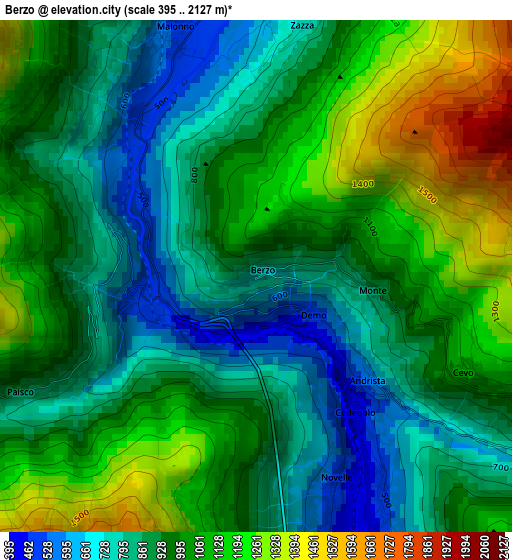
Below is the Elevation map of Berzo, which displays elevation range with different colors. Scale of the first map is from 395 to 2127 m (1296 to 6978 ft) with average elevation of 970.7 meters (=3185 ft) [note 1]
These maps also provides idea of topography and contour of this city, they are displayed at different zoom levels. More info about maps, scale and edge coordinates you can find below images.
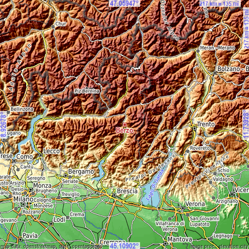
| \ | Map #1 | Topo.Map |
| Scale [m] | 395..2127 m | × |
| Scale [ft] | 1296..6978 ft | × |
| Average | 970.7 m = 3185 ft | × |
| Width | 6.78 km = 4.2 mi | 216.9 km = 134.8 mi |
| Height | 6.78 km = 4.2 mi | 216.9 km = 134.8 mi |
| ↑Max Latitude | 46.123337° | 47.05947° |
| Latitude at center | 46.09287° | 46.09287° |
| ↓Min Latitude | 46.062386° | 45.10902° |
| ← Min Longitude | 10.289085° | 8.92678° |
| Longitude center | 10.33303° | 10.33303° |
| →Max Longitude | 10.376975° | 11.73928° |
Nearby cities:
Cities around Berzo sort by population:
• Edolo elevation 672 m
9.5 km,  0°
0°
• Malonno 525 m
3.4 km,  340°
340°
• Capo di Ponte 368 m
7 km,  173°
173°
• Cedegolo 475 m
2.5 km,  145°
145°
• Ono San Pietro 499 m
8.5 km,  182°
182°
• Sellero 382 m
4.7 km, 166°
• Sonico 641 m
8.3 km,  9°
9°
• Cevo 1072 m
3.1 km,  115°
115°
• Paspardo 976 m
7.3 km,  157°
157°
• Cimbergo 876 m
8.1 km, 161°
• Saviore 1234 m
5.2 km,  105°
105°
• Paisco Loveno 871 m
3.5 km,  243°
243°
Multilingual:
 En español:
Berzo elevación 748 m.
 En France:
Berzo Demo élévation 748 m.


Sources and notes:
- [note 1] Map square and city borders are not equal. Map elevation data is calculated only from area inside that square.
- [src 1] Elevation data from geonames database provided with same terms of usage.
- [src 2] The elevation map of Berzo is generated using elevation data from NASA's 3 arcsec (90m) resolution SRTM data.
- [src 3] Base (background) map © OpenStreetMap contributors tiles are generated by Geofabrik and OpenTopoMap.
Copyright & License:
This Berzo Elevation Map is licensed under CC BY-SA. You may reuse any part from this page, if you give a proper credit by linking to this URL:
 More info on terms of use page.