Stresa elevation
Stresa (Piedmont, Provincia Verbano-Cusio-Ossola), Italy elevation is 218 meters and Stresa elevation in feet is 715 ft above sea level [src 1]. Stresa is a seat of a third-order administrative division (feature code) with elevation that is 104 meters (341 ft) smaller than average city elevation in Italy.
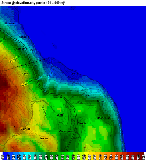
Below is the Elevation map of Stresa, which displays elevation range with different colors. Scale of the first map is from 191 to 949 m (627 to 3114 ft) with average elevation of 367.9 meters (=1207 ft) [note 1]
These maps also provides idea of topography and contour of this city, they are displayed at different zoom levels. More info about maps, scale and edge coordinates you can find below images.
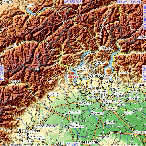
| \ | Map #1 | Map #2 | Topo.Map |
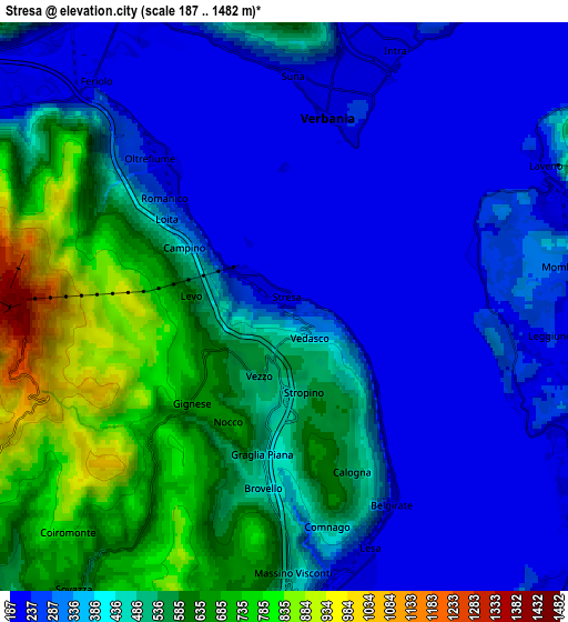
| Scale [m] | 191..949 m | 187..1482 m | × |
| Scale [ft] | 627..3114 ft | 614..4862 ft | × |
| Average | 367.9 m = 1207 ft | 417.8 m = 1371 ft | × |
| Width | 6.8 km = 4.2 mi | 13.61 km = 8.5 mi | 217.7 km = 135.3 mi |
| Height | 6.8 km = 4.2 mi | 13.61 km = 8.5 mi | 217.7 km = 135.3 mi |
| ↑Max Latitude | 45.912164° | 45.942731° | 46.85191° |
| Latitude at center | 45.88158° | 45.88158° | 45.88158° |
| ↓Min Latitude | 45.850979° | 45.820362° | 44.894° |
| ← Min Longitude | 8.494395° | 8.450449° | 7.13209° |
| Longitude center | 8.53834° | 8.53834° | 8.53834° |
| →Max Longitude | 8.582285° | 8.626231° | 9.94459° |
Nearby cities:
Cities around Stresa sort by population:
• Verbania elevation 205 m
4.5 km,  13°
13°
• Pallanza-Intra-Suna 215 m
6.7 km,  21°
21°
• Laveno 201 m
7 km,  64°
64°
• Baveno 229 m
4.2 km,  315°
315°
• Leggiuno 243 m
6.4 km,  95°
95°
• Lesa 210 m
7 km,  166°
166°
• Sangiano 233 m
7.4 km, 95°
• Massino Visconti 453 m
6.4 km,  177°
177°
• Brovello-Carpugnino 450 m
4.4 km,  186°
186°
• Gignese 697 m
3 km,  228°
228°
• Belgirate 237 m
5.1 km,  150°
150°
• Brovello 450 m
4.4 km, 186°
Multilingual:
 En español:
Stresa elevación 218 m.
 En France:
Stresa élévation 218 m.


Sources and notes:
- [note 1] Map square and city borders are not equal. Map elevation data is calculated only from area inside that square.
- [src 1] Elevation data from geonames database provided with same terms of usage.
- [src 2] The elevation map of Stresa is generated using elevation data from NASA's 3 arcsec (90m) resolution SRTM data.
- [src 3] Base (background) map © OpenStreetMap contributors tiles are generated by Geofabrik and OpenTopoMap.
Copyright & License:
This Stresa Elevation Map is licensed under CC BY-SA. You may reuse any part from this page, if you give a proper credit by linking to this URL:
 More info on terms of use page.