Tecchiena elevation
Tecchiena (Latium, Provincia di Frosinone), Italy elevation is 254 meters and Tecchiena elevation in feet is 833 ft above sea level [src 1]. Tecchiena is a populated place (feature code) with elevation that is 68 meters (223 ft) smaller than average city elevation in Italy.
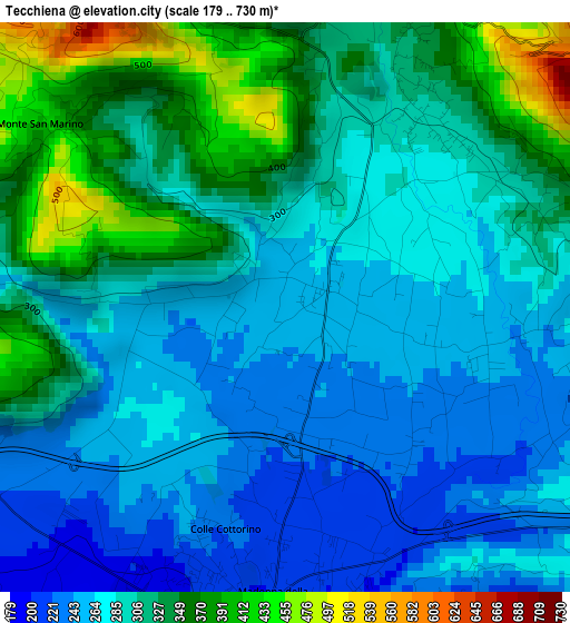
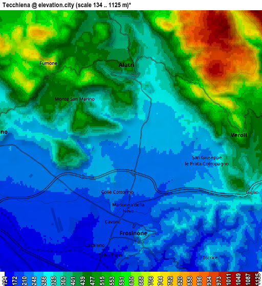
Below is the Elevation map of Tecchiena, which displays elevation range with different colors. Scale of the first map is from 179 to 730 m (587 to 2395 ft) with average elevation of 299 meters (=981 ft) [note 1]
These maps also provides idea of topography and contour of this city, they are displayed at different zoom levels. More info about maps, scale and edge coordinates you can find below images.
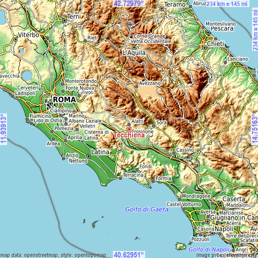
| \ | Map #1 | Map #2 | Topo.Map |
| Scale [m] | 179..730 m | 134..1125 m | × |
| Scale [ft] | 587..2395 ft | 440..3691 ft | × |
| Average | 299 m = 981 ft | 374.7 m = 1229 ft | × |
| Width | 7.3 km = 4.5 mi | 14.6 km = 9.1 mi | 233.5 km = 145.1 mi |
| Height | 7.3 km = 4.5 mi | 14.6 km = 9.1 mi | 233.5 km = 145.1 mi |
| ↑Max Latitude | 41.721029° | 41.753821° | 42.72979° |
| Latitude at center | 41.68822° | 41.68822° | 41.68822° |
| ↓Min Latitude | 41.655394° | 41.622552° | 40.62951° |
| ← Min Longitude | 13.301435° | 13.257489° | 11.93913° |
| Longitude center | 13.34538° | 13.34538° | 13.34538° |
| →Max Longitude | 13.389325° | 13.433271° | 14.75163° |
Nearby cities:
Cities around Tecchiena sort by population:
• Frosinone elevation 183 m
5.4 km,  183°
183°
• Ferentino 340 m
7.4 km,  272°
272°
• Alatri 407 m
4.9 km,  355°
355°
• Veroli 555 m
6 km,  83°
83°
• Sant'Angelo in Villa-Giglio 303 m
7.5 km,  112°
112°
• San Giuseppe le Prata-Cotropagno 239 m
4.4 km, 105°
• Castelmassimo 234 m
4 km,  132°
132°
• Fumone 679 m
8.1 km,  309°
309°
• Monte San Marino 400 m
3.8 km, 313°
• Cartiera-Stazione 152 m
9.4 km,  247°
247°
• Torrice 287 m
7.8 km,  141°
141°
• Collepardo 581 m
8.7 km,  12°
12°
Multilingual:
 En español:
Tecchiena elevación 254 m.
 En France:
Tecchiena élévation 254 m.
 Auf Deutsch:
Tecchiena höhe über dem Meeresspiegel ist 254 m.

Sources and notes:
- [note 1] Map square and city borders are not equal. Map elevation data is calculated only from area inside that square.
- [src 1] Elevation data from geonames database provided with same terms of usage.
- [src 2] The elevation map of Tecchiena is generated using elevation data from NASA's 3 arcsec (90m) resolution SRTM data.
- [src 3] Base (background) map © OpenStreetMap contributors tiles are generated by Geofabrik and OpenTopoMap.
Copyright & License:
This Tecchiena Elevation Map is licensed under CC BY-SA. You may reuse any part from this page, if you give a proper credit by linking to this URL:
 More info on terms of use page.