San Nicolò elevation
San Nicolò (Lombardy, Provincia di Sondrio), Italy elevation is 1335 meters and San Nicolò elevation in feet is 4380 ft above sea level [src 1]. San Nicolò is a seat of a third-order administrative division (feature code) with elevation that is 1013 meters (3323 ft) bigger than average city elevation in Italy.
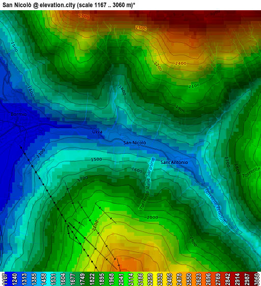
Below is the Elevation map of San Nicolò, which displays elevation range with different colors. Scale of the first map is from 1167 to 3060 m (3829 to 10039 ft) with average elevation of 1831 meters (=6007 ft) [note 1]
These maps also provides idea of topography and contour of this city, they are displayed at different zoom levels. More info about maps, scale and edge coordinates you can find below images.
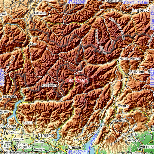
| \ | Map #1 | Topo.Map |
| Scale [m] | 1167..3060 m | × |
| Scale [ft] | 3829..10039 ft | × |
| Average | 1831 m = 6007 ft | × |
| Width | 6.73 km = 4.2 mi | 215.4 km = 133.8 mi |
| Height | 6.73 km = 4.2 mi | 215.4 km = 133.8 mi |
| ↑Max Latitude | 46.493252° | 47.42304° |
| Latitude at center | 46.46299° | 46.46299° |
| ↓Min Latitude | 46.432711° | 45.48571° |
| ← Min Longitude | 10.366035° | 9.00373° |
| Longitude center | 10.40998° | 10.40998° |
| →Max Longitude | 10.453925° | 11.81623° |
Nearby cities:
Cities around San Nicolò sort by population:
• Livigno elevation 1819 m
22.7 km,  291°
291°
• Grosio 666 m
20.9 km,  209°
209°
• Bormio 1204 m
3.1 km,  278°
278°
• Valdisotto 1165 m
5.2 km,  231°
231°
• Sondalo 880 m
16.1 km,  203°
203°
• Prato Allo Stelvio 907 m
22.2 km,  38°
38°
• Cepina 1156 m
5 km, 233°
• Grosotto 603 m
23.2 km, 209°
• Sant'Antonio 1330 m
0.6 km,  110°
110°
• Isolaccia 1356 m
9.3 km, 288°
• Tubre 1246 m
20.5 km,  11°
11°
• Stelvio 1291 m
18.2 km,  34°
34°
Multilingual:
 En español:
San Nicolò elevación 1335 m.
 En France:
San Nicolò élévation 1335 m.
 Auf Deutsch:
San Nicolò höhe über dem Meeresspiegel ist 1335 m.

Sources and notes:
- [note 1] Map square and city borders are not equal. Map elevation data is calculated only from area inside that square.
- [src 1] Elevation data from geonames database provided with same terms of usage.
- [src 2] The elevation map of San Nicolò is generated using elevation data from NASA's 3 arcsec (90m) resolution SRTM data.
- [src 3] Base (background) map © OpenStreetMap contributors tiles are generated by Geofabrik and OpenTopoMap.
Copyright & License:
This San Nicolò Elevation Map is licensed under CC BY-SA. You may reuse any part from this page, if you give a proper credit by linking to this URL:
 More info on terms of use page.