Zanica elevation
Zanica (Lombardy, Provincia di Bergamo), Italy elevation is 210 meters and Zanica elevation in feet is 689 ft above sea level [src 1]. Zanica is a seat of a third-order administrative division (feature code) with elevation that is 112 meters (367 ft) smaller than average city elevation in Italy.
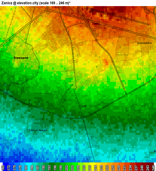
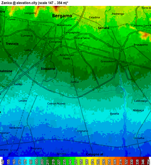
Below is the Elevation map of Zanica, which displays elevation range with different colors. Scale of the first map is from 169 to 246 m (554 to 807 ft) with average elevation of 204.5 meters (=671 ft) [note 1]
These maps also provides idea of topography and contour of this city, they are displayed at different zoom levels. More info about maps, scale and edge coordinates you can find below images.
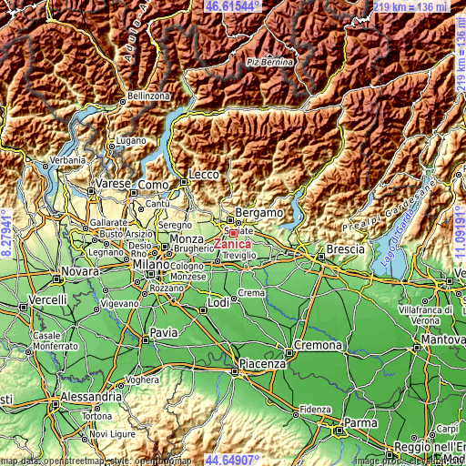
| \ | Map #1 | Map #2 | Topo.Map |
| Scale [m] | 169..246 m | 147..354 m | × |
| Scale [ft] | 554..807 ft | 482..1161 ft | × |
| Average | 204.5 m = 671 ft | 204 m = 669 ft | × |
| Width | 6.83 km = 4.2 mi | 13.67 km = 8.5 mi | 218.6 km = 135.8 mi |
| Height | 6.83 km = 4.2 mi | 13.66 km = 8.5 mi | 218.6 km = 135.8 mi |
| ↑Max Latitude | 45.671596° | 45.702295° | 46.61544° |
| Latitude at center | 45.64088° | 45.64088° | 45.64088° |
| ↓Min Latitude | 45.610147° | 45.579397° | 44.64907° |
| ← Min Longitude | 9.641715° | 9.597769° | 8.27941° |
| Longitude center | 9.68566° | 9.68566° | 9.68566° |
| →Max Longitude | 9.729605° | 9.773551° | 11.09191° |
Nearby cities:
Cities around Zanica sort by population:
• Bergamo elevation 260 m
6.3 km,  346°
346°
• Seriate 249 m
5.8 km,  31°
31°
• Dalmine 205 m
6.2 km,  278°
278°
• Stezzano 211 m
2.8 km,  290°
290°
• Urgnano 173 m
4.7 km,  171°
171°
• Verdello 169 m
6.1 km,  227°
227°
• Azzano San Paolo 222 m
2.1 km,  332°
332°
• Grassobbio 222 m
3.6 km,  60°
60°
• Lallio 212 m
5 km,  298°
298°
• Comun Nuovo 189 m
2.7 km,  222°
222°
• Levate 186 m
5.1 km,  249°
249°
• Orio al Serio 242 m
3.8 km,  6°
6°
Multilingual:
 En español:
Zanica elevación 210 m.
 En France:
Zanica élévation 210 m.


Sources and notes:
- [note 1] Map square and city borders are not equal. Map elevation data is calculated only from area inside that square.
- [src 1] Elevation data from geonames database provided with same terms of usage.
- [src 2] The elevation map of Zanica is generated using elevation data from NASA's 3 arcsec (90m) resolution SRTM data.
- [src 3] Base (background) map © OpenStreetMap contributors tiles are generated by Geofabrik and OpenTopoMap.
Copyright & License:
This Zanica Elevation Map is licensed under CC BY-SA. You may reuse any part from this page, if you give a proper credit by linking to this URL:
 More info on terms of use page.