Orio al Serio elevation
Orio al Serio (Lombardy, Provincia di Bergamo), Italy elevation is 242 meters and Orio al Serio elevation in feet is 794 ft above sea level [src 1]. Orio al Serio is a seat of a third-order administrative division (feature code) with elevation that is 80 meters (262 ft) smaller than average city elevation in Italy.
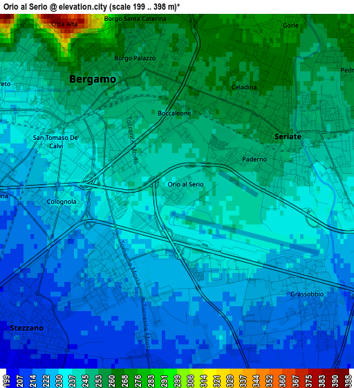
Below is the Elevation map of Orio al Serio, which displays elevation range with different colors. Scale of the first map is from 199 to 398 m (653 to 1306 ft) with average elevation of 237.5 meters (=779 ft) [note 1]
These maps also provides idea of topography and contour of this city, they are displayed at different zoom levels. More info about maps, scale and edge coordinates you can find below images.
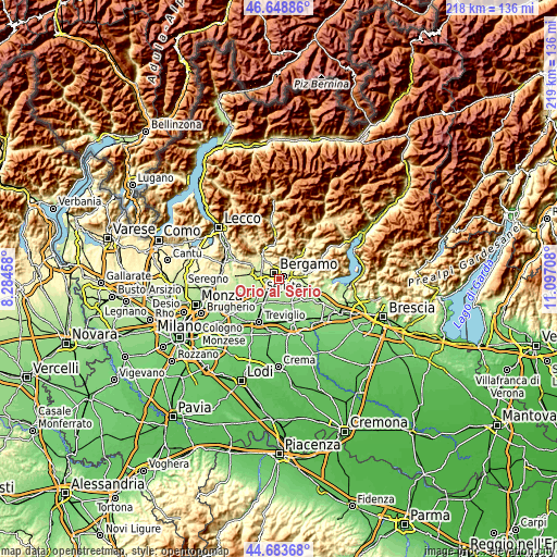
| \ | Map #1 | Topo.Map |
| Scale [m] | 199..398 m | × |
| Scale [ft] | 653..1306 ft | × |
| Average | 237.5 m = 779 ft | × |
| Width | 6.83 km = 4.2 mi | 218.5 km = 135.8 mi |
| Height | 6.83 km = 4.2 mi | 218.5 km = 135.8 mi |
| ↑Max Latitude | 45.705597° | 46.64886° |
| Latitude at center | 45.6749° | 45.6749° |
| ↓Min Latitude | 45.644186° | 44.68368° |
| ← Min Longitude | 9.646885° | 8.28458° |
| Longitude center | 9.69083° | 9.69083° |
| →Max Longitude | 9.734775° | 11.09708° |
Nearby cities:
Cities around Orio al Serio sort by population:
• Bergamo elevation 260 m
3 km,  321°
321°
• Seriate 249 m
2.9 km,  66°
66°
• Stezzano 211 m
4.1 km,  227°
227°
• Torre Boldone 286 m
4.9 km,  15°
15°
• Zanica 210 m
3.8 km,  186°
186°
• Azzano San Paolo 222 m
2.3 km,  216°
216°
• Gorle 270 m
3.4 km,  31°
31°
• Scanzo-Rosciate 276 m
5.3 km,  40°
40°
• Grassobbio 222 m
3.4 km,  126°
126°
• Pedrengo 259 m
4.2 km,  55°
55°
• Brusaporto 234 m
5.4 km,  94°
94°
• Lallio 212 m
5 km,  254°
254°
Multilingual:
 En español:
Orio al Serio elevación 242 m.
 En France:
Orio al Serio élévation 242 m.
 Auf Deutsch:
Orio al Serio höhe über dem Meeresspiegel ist 242 m.

Sources and notes:
- [note 1] Map square and city borders are not equal. Map elevation data is calculated only from area inside that square.
- [src 1] Elevation data from geonames database provided with same terms of usage.
- [src 2] The elevation map of Orio al Serio is generated using elevation data from NASA's 3 arcsec (90m) resolution SRTM data.
- [src 3] Base (background) map © OpenStreetMap contributors tiles are generated by Geofabrik and OpenTopoMap.
Copyright & License:
This Orio al Serio Elevation Map is licensed under CC BY-SA. You may reuse any part from this page, if you give a proper credit by linking to this URL:
 More info on terms of use page.