Cortale elevation
Cortale (Calabria, Provincia di Catanzaro), Italy elevation is 428 meters and Cortale elevation in feet is 1404 ft above sea level [src 1]. Cortale is a seat of a third-order administrative division (feature code) with elevation that is 106 meters (348 ft) bigger than average city elevation in Italy.
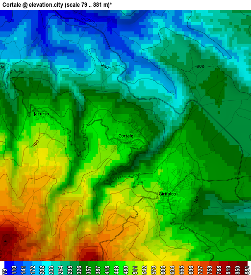
Below is the Elevation map of Cortale, which displays elevation range with different colors. Scale of the first map is from 79 to 881 m (259 to 2890 ft) with average elevation of 383 meters (=1257 ft) [note 1]
These maps also provides idea of topography and contour of this city, they are displayed at different zoom levels. More info about maps, scale and edge coordinates you can find below images.
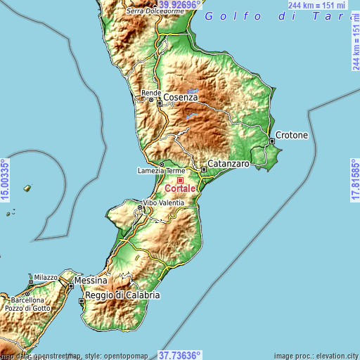
| \ | Map #1 | Topo.Map |
| Scale [m] | 79..881 m | × |
| Scale [ft] | 259..2890 ft | × |
| Average | 383 m = 1257 ft | × |
| Width | 7.61 km = 4.7 mi | 243.6 km = 151.4 mi |
| Height | 7.61 km = 4.7 mi | 243.6 km = 151.4 mi |
| ↑Max Latitude | 38.874311° | 39.92696° |
| Latitude at center | 38.84009° | 38.84009° |
| ↓Min Latitude | 38.805853° | 37.73636° |
| ← Min Longitude | 16.365655° | 15.00335° |
| Longitude center | 16.4096° | 16.4096° |
| →Max Longitude | 16.453545° | 17.81585° |
Nearby cities:
Cities around Cortale sort by population:
• Girifalco elevation 453 m
2.2 km,  136°
136°
• Borgia 338 m
8.6 km,  100°
100°
• San Pietro a Maida 319 m
6 km,  277°
277°
• Maida 255 m
4.6 km,  297°
297°
• Curinga 433 m
8.4 km,  260°
260°
• Vallefiorita 306 m
8.4 km,  147°
147°
• Amaroni 369 m
6.1 km, 146°
• Squillace 290 m
11 km,  126°
126°
• Caraffa di Catanzaro 360 m
8.1 km,  55°
55°
• Palermiti 519 m
10.8 km,  160°
160°
• Jacurso 439 m
2.7 km,  285°
285°
• San Floro 269 m
9.5 km,  91°
91°
Multilingual:
 En español:
Cortale elevación 428 m.
 En France:
Cortale élévation 428 m.


Sources and notes:
- [note 1] Map square and city borders are not equal. Map elevation data is calculated only from area inside that square.
- [src 1] Elevation data from geonames database provided with same terms of usage.
- [src 2] The elevation map of Cortale is generated using elevation data from NASA's 3 arcsec (90m) resolution SRTM data.
- [src 3] Base (background) map © OpenStreetMap contributors tiles are generated by Geofabrik and OpenTopoMap.
Copyright & License:
This Cortale Elevation Map is licensed under CC BY-SA. You may reuse any part from this page, if you give a proper credit by linking to this URL:
 More info on terms of use page.