San Pietro a Maida elevation
San Pietro a Maida (Calabria, Provincia di Catanzaro), Italy elevation is 319 meters and San Pietro a Maida elevation in feet is 1047 ft above sea level [src 1]. San Pietro a Maida is a seat of a third-order administrative division (feature code) with elevation that is 3 meters (10 ft) smaller than average city elevation in Italy.
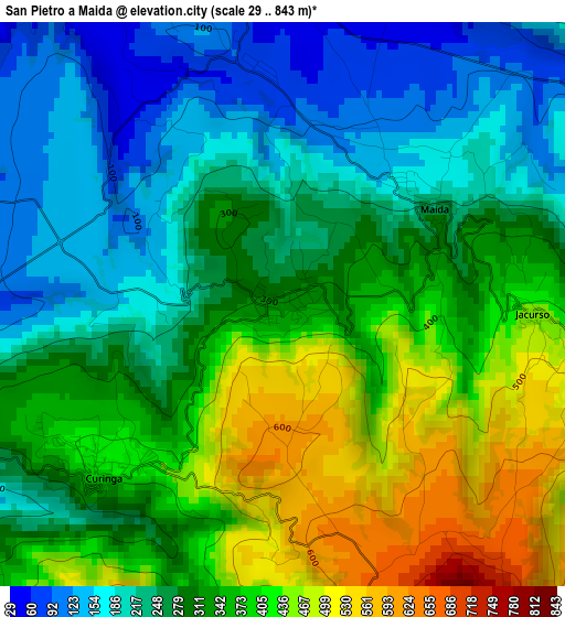
Below is the Elevation map of San Pietro a Maida, which displays elevation range with different colors. Scale of the first map is from 29 to 843 m (95 to 2766 ft) with average elevation of 311 meters (=1020 ft) [note 1]
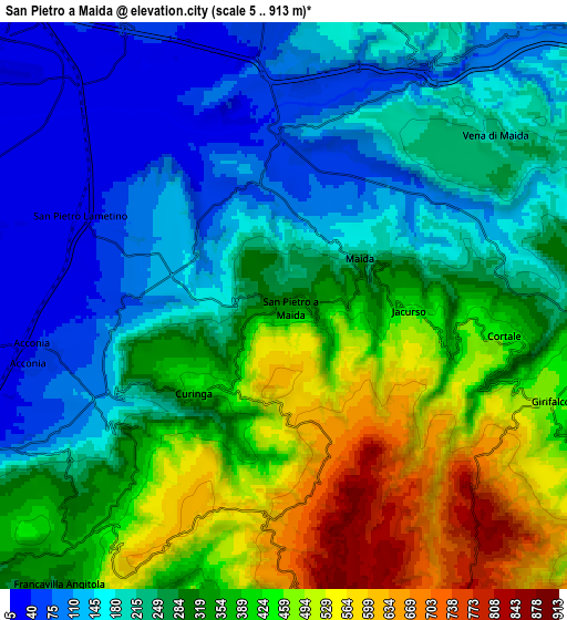
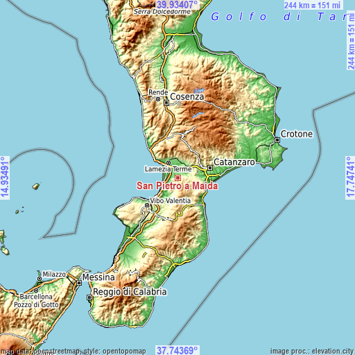
These maps also provides idea of topography and contour of this city, they are displayed at different zoom levels. More info about maps, scale and edge coordinates you can find below images.
| \ | Map #1 | Map #2 | Topo.Map |
| Scale [m] | 29..843 m | 5..913 m | × |
| Scale [ft] | 95..2766 ft | 16..2995 ft | × |
| Average | 311 m = 1020 ft | 295.1 m = 968 ft | × |
| Width | 7.61 km = 4.7 mi | 15.22 km = 9.5 mi | 243.5 km = 151.3 mi |
| Height | 7.61 km = 4.7 mi | 15.22 km = 9.5 mi | 243.5 km = 151.3 mi |
| ↑Max Latitude | 38.881527° | 38.915728° | 39.93407° |
| Latitude at center | 38.84731° | 38.84731° | 38.84731° |
| ↓Min Latitude | 38.813076° | 38.778826° | 37.74369° |
| ← Min Longitude | 16.297215° | 16.253269° | 14.93491° |
| Longitude center | 16.34116° | 16.34116° | 16.34116° |
| →Max Longitude | 16.385105° | 16.429051° | 17.74741° |
Nearby cities:
Cities around San Pietro a Maida sort by population:
• Girifalco elevation 453 m
7.8 km,  107°
107°
• Santa Eufemia Lamezia 23 m
11.1 km,  316°
316°
• Maida 255 m
2.3 km,  55°
55°
• Filadelfia 583 m
8.2 km,  211°
211°
• Curinga 433 m
3.2 km,  228°
228°
• Pianopoli 239 m
12.4 km,  19°
19°
• Cortale 428 m
6 km,  97°
97°
• Acconia 42 m
6.7 km,  259°
259°
• Amaroni 369 m
11 km,  122°
122°
• Francavilla Angitola 312 m
9.6 km,  218°
218°
• Jacurso 439 m
3.3 km,  91°
91°
• Polia 382 m
11 km,  193°
193°
Multilingual:
 En español:
San Pietro a Maida elevación 319 m.
 En France:
San Pietro a Maida élévation 319 m.
 Auf Deutsch:
San Pietro a Maida höhe über dem Meeresspiegel ist 319 m.
 На русском:
San Pietro a Maida высота над уровнем моря 319 м
Sources and notes:
- [note 1] Map square and city borders are not equal. Map elevation data is calculated only from area inside that square.
- [src 1] Elevation data from geonames database provided with same terms of usage.
- [src 2] The elevation map of San Pietro a Maida is generated using elevation data from NASA's 3 arcsec (90m) resolution SRTM data.
- [src 3] Base (background) map © OpenStreetMap contributors tiles are generated by Geofabrik and OpenTopoMap.
Copyright & License:
This San Pietro a Maida Elevation Map is licensed under CC BY-SA. You may reuse any part from this page, if you give a proper credit by linking to this URL:
 More info on terms of use page.