Borgia elevation
Borgia (Calabria, Provincia di Catanzaro), Italy elevation is 338 meters and Borgia elevation in feet is 1109 ft above sea level [src 1]. Borgia is a seat of a third-order administrative division (feature code) with elevation that is 16 meters (52 ft) bigger than average city elevation in Italy.
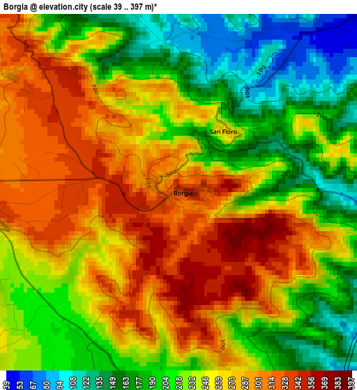
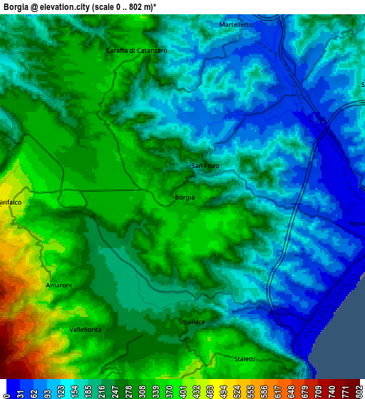
Below is the Elevation map of Borgia, which displays elevation range with different colors. Scale of the first map is from 39 to 397 m (128 to 1302 ft) with average elevation of 240.7 meters (=790 ft) [note 1]
These maps also provides idea of topography and contour of this city, they are displayed at different zoom levels. More info about maps, scale and edge coordinates you can find below images.
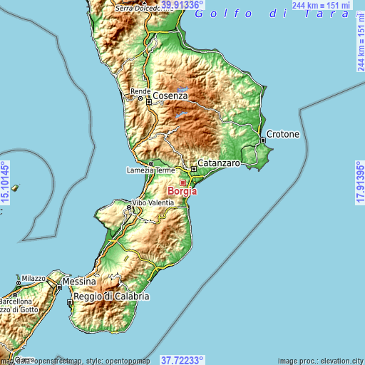
| \ | Map #1 | Map #2 | Topo.Map |
| Scale [m] | 39..397 m | 0..802 m | × |
| Scale [ft] | 128..1302 ft | 0..2631 ft | × |
| Average | 240.7 m = 790 ft | 232.4 m = 762 ft | × |
| Width | 7.61 km = 4.7 mi | 15.23 km = 9.5 mi | 243.6 km = 151.4 mi |
| Height | 7.61 km = 4.7 mi | 15.23 km = 9.5 mi | 243.6 km = 151.4 mi |
| ↑Max Latitude | 38.860497° | 38.894708° | 39.91336° |
| Latitude at center | 38.82627° | 38.82627° | 38.82627° |
| ↓Min Latitude | 38.792026° | 38.757766° | 37.72233° |
| ← Min Longitude | 16.463755° | 16.419809° | 15.10145° |
| Longitude center | 16.5077° | 16.5077° | 16.5077° |
| →Max Longitude | 16.551645° | 16.595591° | 17.91395° |
Nearby cities:
Cities around Borgia sort by population:
• Girifalco elevation 453 m
7 km,  269°
269°
• Cortale 428 m
8.6 km,  280°
280°
• Roccelletta 7 m
8 km,  102°
102°
• Vallefiorita 306 m
6.9 km,  216°
216°
• Staletti 377 m
7.4 km,  158°
158°
• Amaroni 369 m
6.3 km,  235°
235°
• Squillace 290 m
5.1 km,  176°
176°
• Caraffa di Catanzaro 360 m
6.5 km,  343°
343°
• Squillace Lido 6 m
7.6 km,  134°
134°
• Settingiano 245 m
9.5 km,  3°
3°
• Montauro 405 m
8.6 km, 177°
• San Floro 269 m
1.6 km,  36°
36°
Multilingual:
 En español:
Borgia elevación 338 m.
 En France:
Borgia élévation 338 m.


Sources and notes:
- [note 1] Map square and city borders are not equal. Map elevation data is calculated only from area inside that square.
- [src 1] Elevation data from geonames database provided with same terms of usage.
- [src 2] The elevation map of Borgia is generated using elevation data from NASA's 3 arcsec (90m) resolution SRTM data.
- [src 3] Base (background) map © OpenStreetMap contributors tiles are generated by Geofabrik and OpenTopoMap.
Copyright & License:
This Borgia Elevation Map is licensed under CC BY-SA. You may reuse any part from this page, if you give a proper credit by linking to this URL:
 More info on terms of use page.