Malvito elevation
Malvito (Calabria, Provincia di Cosenza), Italy elevation is 372 meters and Malvito elevation in feet is 1220 ft above sea level [src 1]. Malvito is a seat of a third-order administrative division (feature code) with elevation that is 50 meters (164 ft) bigger than average city elevation in Italy.
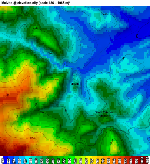
Below is the Elevation map of Malvito, which displays elevation range with different colors. Scale of the first map is from 186 to 1065 m (610 to 3494 ft) with average elevation of 450.6 meters (=1478 ft) [note 1]
These maps also provides idea of topography and contour of this city, they are displayed at different zoom levels. More info about maps, scale and edge coordinates you can find below images.
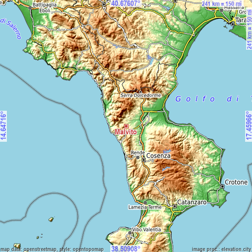
| \ | Map #1 | Topo.Map |
| Scale [m] | 186..1065 m | × |
| Scale [ft] | 610..3494 ft | × |
| Average | 450.6 m = 1478 ft | × |
| Width | 7.53 km = 4.7 mi | 240.9 km = 149.7 mi |
| Height | 7.53 km = 4.7 mi | 240.9 km = 149.7 mi |
| ↑Max Latitude | 39.634902° | 40.67607° |
| Latitude at center | 39.60105° | 39.60105° |
| ↓Min Latitude | 39.567182° | 38.50908° |
| ← Min Longitude | 16.009465° | 14.64716° |
| Longitude center | 16.05341° | 16.05341° |
| →Max Longitude | 16.097355° | 17.45966° |
Nearby cities:
Cities around Malvito sort by population:
• Roggiano Gravina elevation 221 m
9.5 km,  78°
78°
• Fagnano Castello 478 m
3.4 km,  166°
166°
• San Marco Argentano 413 m
7.8 km,  128°
128°
• San Sosti 354 m
6.7 km,  342°
342°
• Sant'Agata di Esaro 479 m
6.5 km,  291°
291°
• Mottafollone 374 m
5.4 km,  10°
10°
• Cerzeto 450 m
11.7 km,  152°
152°
• Mongrassano 517 m
9.7 km, 148°
• San Donato di Ninea 800 m
12.3 km,  357°
357°
• Sangineto 280 m
11.9 km,  272°
272°
• Cervicati 475 m
9.1 km,  136°
136°
• Santa Caterina Albanese 461 m
2.2 km, 139°
Multilingual:
 En español:
Malvito elevación 372 m.
 En France:
Malvito élévation 372 m.


Sources and notes:
- [note 1] Map square and city borders are not equal. Map elevation data is calculated only from area inside that square.
- [src 1] Elevation data from geonames database provided with same terms of usage.
- [src 2] The elevation map of Malvito is generated using elevation data from NASA's 3 arcsec (90m) resolution SRTM data.
- [src 3] Base (background) map © OpenStreetMap contributors tiles are generated by Geofabrik and OpenTopoMap.
Copyright & License:
This Malvito Elevation Map is licensed under CC BY-SA. You may reuse any part from this page, if you give a proper credit by linking to this URL:
 More info on terms of use page.