Mongrassano elevation
Mongrassano (Calabria, Provincia di Cosenza), Italy elevation is 517 meters and Mongrassano elevation in feet is 1696 ft above sea level [src 1]. Mongrassano is a seat of a third-order administrative division (feature code) with elevation that is 195 meters (640 ft) bigger than average city elevation in Italy.
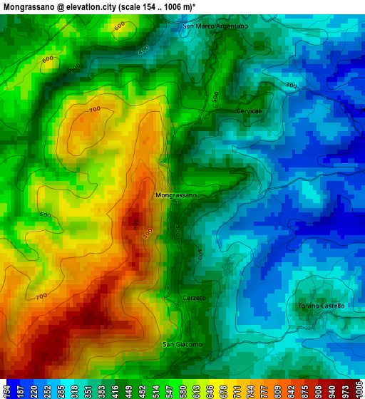
Below is the Elevation map of Mongrassano, which displays elevation range with different colors. Scale of the first map is from 154 to 1006 m (505 to 3301 ft) with average elevation of 477.4 meters (=1566 ft) [note 1]
These maps also provides idea of topography and contour of this city, they are displayed at different zoom levels. More info about maps, scale and edge coordinates you can find below images.
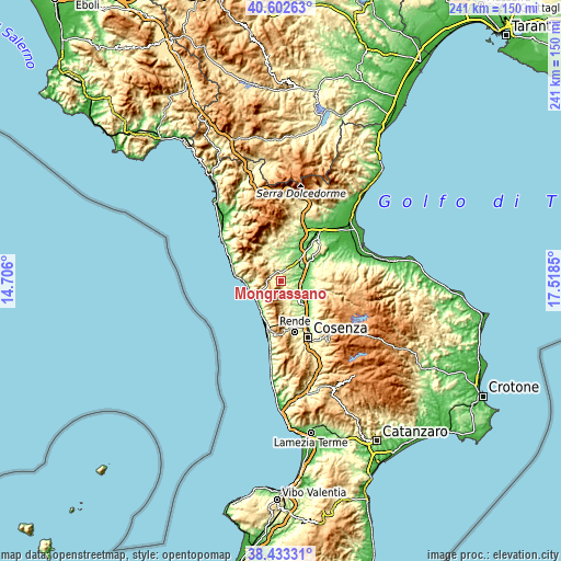
| \ | Map #1 | Topo.Map |
| Scale [m] | 154..1006 m | × |
| Scale [ft] | 505..3301 ft | × |
| Average | 477.4 m = 1566 ft | × |
| Width | 7.54 km = 4.7 mi | 241.2 km = 149.9 mi |
| Height | 7.54 km = 4.7 mi | 241.2 km = 149.9 mi |
| ↑Max Latitude | 39.560328° | 40.60263° |
| Latitude at center | 39.52644° | 39.52644° |
| ↓Min Latitude | 39.492535° | 38.43331° |
| ← Min Longitude | 16.068305° | 14.706° |
| Longitude center | 16.11225° | 16.11225° |
| →Max Longitude | 16.156195° | 17.5185° |
Nearby cities:
Cities around Mongrassano sort by population:
• Roggiano Gravina elevation 221 m
11 km,  22°
22°
• Fagnano Castello 478 m
6.6 km,  319°
319°
• San Marco Argentano 413 m
3.6 km, 17°
• Torano Castello 347 m
4.9 km,  120°
120°
• Sartano 257 m
6 km,  105°
105°
• Lattarico 415 m
8.5 km,  171°
171°
• Rota Greca 491 m
6.6 km,  178°
178°
• Cerzeto 450 m
2.1 km, 171°
• San Martino di Finita 502 m
4.1 km, 183°
• Cervicati 475 m
2.2 km,  35°
35°
• Malvito 372 m
9.7 km,  328°
328°
• Santa Caterina Albanese 461 m
7.5 km, 331°
Multilingual:
 En español:
Mongrassano elevación 517 m.
 En France:
Mongrassano élévation 517 m.
 Auf Deutsch:
Mongrassano höhe über dem Meeresspiegel ist 517 m.

Sources and notes:
- [note 1] Map square and city borders are not equal. Map elevation data is calculated only from area inside that square.
- [src 1] Elevation data from geonames database provided with same terms of usage.
- [src 2] The elevation map of Mongrassano is generated using elevation data from NASA's 3 arcsec (90m) resolution SRTM data.
- [src 3] Base (background) map © OpenStreetMap contributors tiles are generated by Geofabrik and OpenTopoMap.
Copyright & License:
This Mongrassano Elevation Map is licensed under CC BY-SA. You may reuse any part from this page, if you give a proper credit by linking to this URL:
 More info on terms of use page.