Germī elevation
Germī (Ardabīl), Iran elevation is 854 meters and Germī elevation in feet is 2802 ft above sea level [src 1]. Germī is a seat of a second-order administrative division (feature code) with elevation that is 190 meters (623 ft) smaller than average city elevation in Iran.
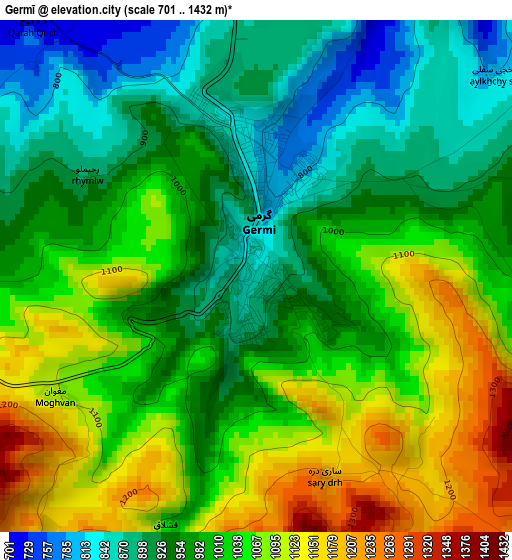
Below is the Elevation map of Germī, which displays elevation range with different colors. Scale of the first map is from 701 to 1432 m (2300 to 4698 ft) with average elevation of 999.7 meters (=3280 ft) [note 1]
These maps also provides idea of topography and contour of this city, they are displayed at different zoom levels. More info about maps, scale and edge coordinates you can find below images.
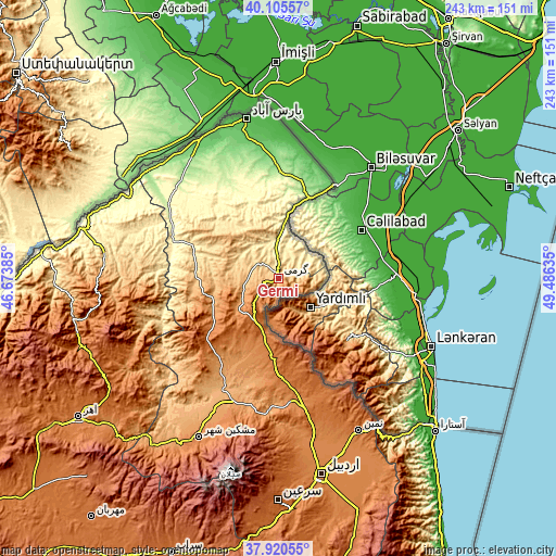
| \ | Map #1 | Topo.Map |
| Scale [m] | 701..1432 m | × |
| Scale [ft] | 2300..4698 ft | × |
| Average | 999.7 m = 3280 ft | × |
| Width | 7.59 km = 4.7 mi | 243 km = 151 mi |
| Height | 7.59 km = 4.7 mi | 242.9 km = 150.9 mi |
| ↑Max Latitude | 39.055633° | 40.10557° |
| Latitude at center | 39.0215° | 39.0215° |
| ↓Min Latitude | 38.98735° | 37.92055° |
| ← Min Longitude | 48.036155° | 46.67385° |
| Longitude center | 48.0801° | 48.0801° |
| →Max Longitude | 48.124045° | 49.48635° |
Nearby cities:
Cities around Germī sort by population:
• Ardabīl elevation 1353 m
87.8 km,  167°
167°
• Pārsābād 46 m
71.1 km,  348°
348°
• Ahar 1336 m
106.5 km,  235°
235°
• Āstārā -24 m
95.2 km,  133°
133°
• Bīleh Savār 83 m
46.3 km,  30°
30°
• Omīdcheh 1502 m
81.9 km,  176°
176°
• Herīs 1904 m
120 km,  224°
224°
• Nīr 1623 m
110 km, 183°
• Kaleybar 1148 m
91.7 km,  259°
259°
• Khomārlū 391 m
91.3 km,  278°
278°
• Meshgīn Shahr 1421 m
77.4 km,  206°
206°
• Namīn 1429 m
74.8 km,  152°
152°
Multilingual:
 En español:
Germī elevación 854 m.
 En France:
Germī élévation 854 m.


Sources and notes:
- [note 1] Map square and city borders are not equal. Map elevation data is calculated only from area inside that square.
- [src 1] Elevation data from geonames database provided with same terms of usage.
- [src 2] The elevation map of Germī is generated using elevation data from NASA's 3 arcsec (90m) resolution SRTM data.
- [src 3] Base (background) map © OpenStreetMap contributors tiles are generated by Geofabrik and OpenTopoMap.
Copyright & License:
This Germī Elevation Map is licensed under CC BY-SA. You may reuse any part from this page, if you give a proper credit by linking to this URL:
 More info on terms of use page.