Ardabīl elevation
Ardabīl, Iran elevation is 1353 meters and Ardabīl elevation in feet is 4439 ft above sea level [src 1]. Ardabīl is a seat of a first-order administrative division (feature code) with elevation that is 309 meters (1014 ft) bigger than average city elevation in Iran.
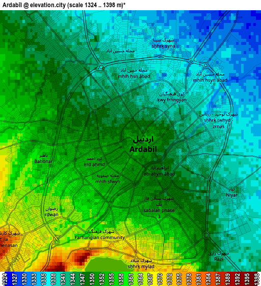
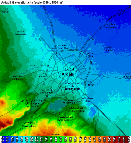
Below is the Elevation map of Ardabīl, which displays elevation range with different colors. Scale of the first map is from 1324 to 1398 m (4344 to 4587 ft) with average elevation of 1348.3 meters (=4424 ft) [note 1]
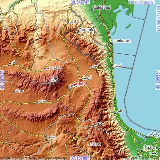
These maps also provides idea of topography and contour of this city, they are displayed at different zoom levels. More info about maps, scale and edge coordinates you can find below images.
| \ | Map #1 | Map #2 | Topo.Map |
| Scale [m] | 1324..1398 m | 1310..1534 m | × |
| Scale [ft] | 4344..4587 ft | 4298..5033 ft | × |
| Average | 1348.3 m = 4424 ft | 1359.6 m = 4461 ft | × |
| Width | 7.67 km = 4.8 mi | 15.35 km = 9.5 mi | 245.6 km = 152.6 mi |
| Height | 7.67 km = 4.8 mi | 15.35 km = 9.5 mi | 245.6 km = 152.6 mi |
| ↑Max Latitude | 38.284303° | 38.318789° | 39.34574° |
| Latitude at center | 38.2498° | 38.2498° | 38.2498° |
| ↓Min Latitude | 38.215281° | 38.180745° | 37.13708° |
| ← Min Longitude | 48.249355° | 48.205409° | 46.88705° |
| Longitude center | 48.2933° | 48.2933° | 48.2933° |
| →Max Longitude | 48.337245° | 48.381191° | 49.69955° |
Nearby cities:
Cities around Ardabīl sort by population:
• Khalkhāl elevation 1795 m
73.2 km,  163°
163°
• Hashtpar 57 m
73.6 km,  133°
133°
• Āstārā -24 m
54.3 km,  68°
68°
• Omīdcheh 1502 m
13.9 km,  287°
287°
• Mīāneh 1097 m
105.2 km,  208°
208°
• Herīs 1904 m
102.7 km,  269°
269°
• Germī 854 m
87.8 km,  347°
347°
• Sarāb 1682 m
74.6 km,  242°
242°
• Gīvī 1360 m
62.9 km,  176°
176°
• Meshgīn Shahr 1421 m
55.8 km, 287°
• Nīr 1623 m
35.2 km,  227°
227°
• Namīn 1429 m
25.8 km,  40°
40°
Multilingual:
 En español:
Ardabīl elevación 1353 m.
 En France:
Ardabil élévation 1353 m.
 Auf Deutsch:
Ardabil höhe über dem Meeresspiegel ist 1353 m.

Sources and notes:
- [note 1] Map square and city borders are not equal. Map elevation data is calculated only from area inside that square.
- [src 1] Elevation data from geonames database provided with same terms of usage.
- [src 2] The elevation map of Ardabīl is generated using elevation data from NASA's 3 arcsec (90m) resolution SRTM data.
- [src 3] Base (background) map © OpenStreetMap contributors tiles are generated by Geofabrik and OpenTopoMap.
Copyright & License:
This Ardabīl Elevation Map is licensed under CC BY-SA. You may reuse any part from this page, if you give a proper credit by linking to this URL:
 More info on terms of use page.