Āstārā elevation
Āstārā (Gīlān, Shahrestān-e Āstārā), Iran elevation is -24 meters and Āstārā elevation in feet is -79 ft above sea level [src 1]. Āstārā is a seat of a second-order administrative division (feature code) with elevation that is 1068 meters (3504 ft) smaller than average city elevation in Iran.
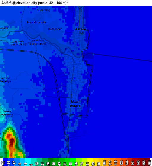
Below is the Elevation map of Āstārā, which displays elevation range with different colors. Scale of the first map is from -32 to 164 m (-105 to 538 ft) with average elevation of -23.3 meters (=-76 ft) [note 1]
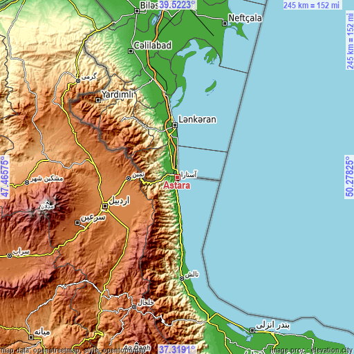
These maps also provides idea of topography and contour of this city, they are displayed at different zoom levels. More info about maps, scale and edge coordinates you can find below images.
| \ | Map #1 | Map #2 | Topo.Map |
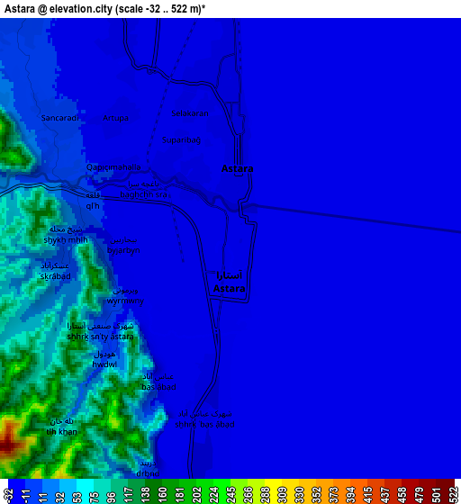
| Scale [m] | -32..164 m | -32..522 m | × |
| Scale [ft] | -105..538 ft | -105..1713 ft | × |
| Average | -23.3 m = -76 ft | -2.7 m = -9 ft | × |
| Width | 7.66 km = 4.8 mi | 15.31 km = 9.5 mi | 245 km = 152.2 mi |
| Height | 7.66 km = 4.8 mi | 15.31 km = 9.5 mi | 245 km = 152.2 mi |
| ↑Max Latitude | 38.463518° | 38.497919° | 39.5223° |
| Latitude at center | 38.4291° | 38.4291° | 38.4291° |
| ↓Min Latitude | 38.394666° | 38.360216° | 37.3191° |
| ← Min Longitude | 48.828055° | 48.784109° | 47.46575° |
| Longitude center | 48.872° | 48.872° | 48.872° |
| →Max Longitude | 48.915945° | 48.959891° | 50.27825° |
Nearby cities:
Cities around Āstārā sort by population:
• Ardabīl elevation 1353 m
54.3 km,  248°
248°
• Khalkhāl 1795 m
95 km,  198°
198°
• Hashtpar 57 m
70.4 km,  177°
177°
• Bīleh Savār 83 m
114.8 km,  337°
337°
• Ziabar (Gaskar) -12 m
116.2 km,  163°
163°
• Omīdcheh 1502 m
65.6 km,  256°
256°
• Meshgīn Shahr 1421 m
103.7 km,  268°
268°
• Reẕvānshahr 15 m
100.5 km,  166°
166°
• Germī 854 m
95.2 km,  313°
313°
• Gīvī 1360 m
94.8 km,  209°
209°
• Nīr 1623 m
88 km,  240°
240°
• Namīn 1429 m
33.8 km, 269°
Multilingual:
 En español:
Āstārā elevación -24 m.
 En France:
Āstārā élévation -24 m.


Sources and notes:
- [note 1] Map square and city borders are not equal. Map elevation data is calculated only from area inside that square.
- [src 1] Elevation data from geonames database provided with same terms of usage.
- [src 2] The elevation map of Āstārā is generated using elevation data from NASA's 3 arcsec (90m) resolution SRTM data.
- [src 3] Base (background) map © OpenStreetMap contributors tiles are generated by Geofabrik and OpenTopoMap.
Copyright & License:
This Āstārā Elevation Map is licensed under CC BY-SA. You may reuse any part from this page, if you give a proper credit by linking to this URL:
 More info on terms of use page.