Ahar elevation
Ahar (East Azerbaijan), Iran elevation is 1336 meters and Ahar elevation in feet is 4383 ft above sea level [src 1]. Ahar is a seat of a second-order administrative division (feature code) with elevation that is 292 meters (958 ft) bigger than average city elevation in Iran.
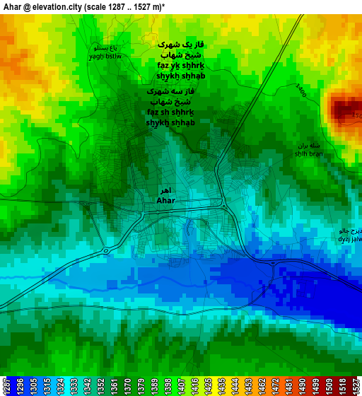
Below is the Elevation map of Ahar, which displays elevation range with different colors. Scale of the first map is from 1287 to 1527 m (4222 to 5010 ft) with average elevation of 1368.5 meters (=4490 ft) [note 1]
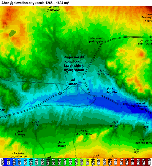
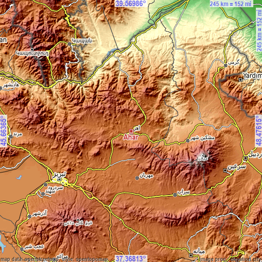
These maps also provides idea of topography and contour of this city, they are displayed at different zoom levels. More info about maps, scale and edge coordinates you can find below images.
| \ | Map #1 | Map #2 | Topo.Map |
| Scale [m] | 1287..1527 m | 1268..1694 m | × |
| Scale [ft] | 4222..5010 ft | 4160..5558 ft | × |
| Average | 1368.5 m = 4490 ft | 1438.8 m = 4720 ft | × |
| Width | 7.65 km = 4.8 mi | 15.3 km = 9.5 mi | 244.8 km = 152.1 mi |
| Height | 7.65 km = 4.8 mi | 15.3 km = 9.5 mi | 244.8 km = 152.1 mi |
| ↑Max Latitude | 38.511795° | 38.546173° | 39.56986° |
| Latitude at center | 38.4774° | 38.4774° | 38.4774° |
| ↓Min Latitude | 38.442989° | 38.408562° | 37.36813° |
| ← Min Longitude | 47.025955° | 46.982009° | 45.66365° |
| Longitude center | 47.0699° | 47.0699° | 47.0699° |
| →Max Longitude | 47.113845° | 47.157791° | 48.47615° |
Nearby cities:
Cities around Ahar sort by population:
• Tabriz elevation 1396 m
81 km,  236°
236°
• Omīdcheh 1502 m
95.8 km,  102°
102°
• Germī 854 m
106.5 km,  55°
55°
• Oskū 1512 m
103.7 km,  232°
232°
• Nīr 1623 m
94.9 km,  121°
121°
• Varazqān 1532 m
86.1 km,  284°
284°
• Khomārlū 391 m
74.7 km,  357°
357°
• Bostānābād 1725 m
73.1 km,  196°
196°
• Sarāb 1682 m
72.3 km,  145°
145°
• Meshgīn Shahr 1421 m
54 km, 99°
• Kaleybar 1148 m
43.2 km, 356°
• Herīs 1904 m
25.8 km,  170°
170°
Multilingual:
 En español:
Ahar elevación 1336 m.
 En France:
Ahar élévation 1336 m.


Sources and notes:
- [note 1] Map square and city borders are not equal. Map elevation data is calculated only from area inside that square.
- [src 1] Elevation data from geonames database provided with same terms of usage.
- [src 2] The elevation map of Ahar is generated using elevation data from NASA's 3 arcsec (90m) resolution SRTM data.
- [src 3] Base (background) map © OpenStreetMap contributors tiles are generated by Geofabrik and OpenTopoMap.
Copyright & License:
This Ahar Elevation Map is licensed under CC BY-SA. You may reuse any part from this page, if you give a proper credit by linking to this URL:
 More info on terms of use page.