Noşratābād elevation
Noşratābād (Sistan and Baluchestan), Iran elevation is 1112 meters and Noşratābād elevation in feet is 3648 ft above sea level [src 1]. Noşratābād is a populated place (feature code) with elevation that is 68 meters (223 ft) bigger than average city elevation in Iran.
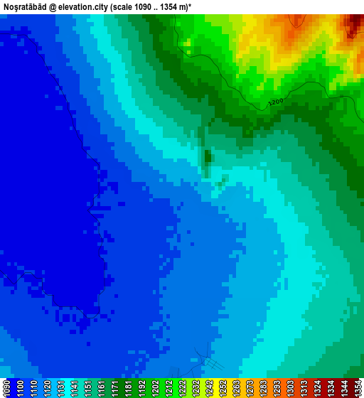
Below is the Elevation map of Noşratābād, which displays elevation range with different colors. Scale of the first map is from 1090 to 1354 m (3576 to 4442 ft) with average elevation of 1137.6 meters (=3732 ft) [note 1]
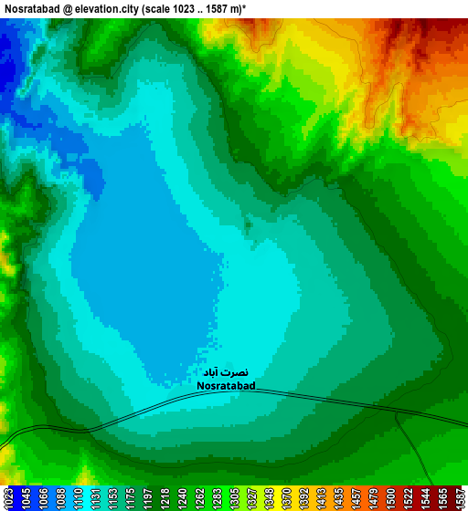
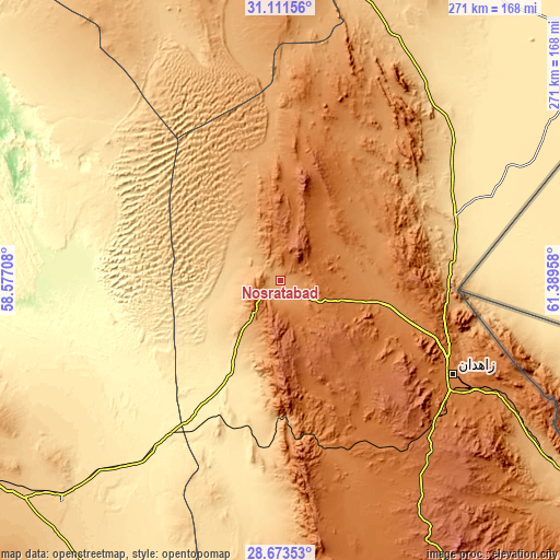
These maps also provides idea of topography and contour of this city, they are displayed at different zoom levels. More info about maps, scale and edge coordinates you can find below images.
| \ | Map #1 | Map #2 | Topo.Map |
| Scale [m] | 1090..1354 m | 1023..1587 m | × |
| Scale [ft] | 3576..4442 ft | 3356..5207 ft | × |
| Average | 1137.6 m = 3732 ft | 1199.3 m = 3935 ft | × |
| Width | 8.47 km = 5.3 mi | 16.94 km = 10.5 mi | 271.1 km = 168.5 mi |
| Height | 8.47 km = 5.3 mi | 16.94 km = 10.5 mi | 271.1 km = 168.5 mi |
| ↑Max Latitude | 29.938089° | 29.976163° | 31.11156° |
| Latitude at center | 29.9° | 29.9° | 29.9° |
| ↓Min Latitude | 29.861897° | 29.823779° | 28.67353° |
| ← Min Longitude | 59.939385° | 59.895439° | 58.57708° |
| Longitude center | 59.98333° | 59.98333° | 59.98333° |
| →Max Longitude | 60.027275° | 60.071221° | 61.38958° |
Nearby cities:
Cities around Noşratābād sort by population:
• Zahedan elevation 1380 m
96.1 km,  117°
117°
• Zābol 483 m
191.8 km,  49°
49°
• Bam 1061 m
180.5 km,  240°
240°
• Khāsh 1413 m
221.8 km,  147°
147°
• ‘Anbarābād 603 m
260.8 km,  232°
232°
• Jīroft 680 m
256.4 km, 238°
• Dūst Moḩammad Khān 483 m
221.8 km, 51°
• Zehak 496 m
196.7 km,  55°
55°
• Nehbandān 1187 m
182.6 km,  1°
1°
• Narmāshīr 759 m
163.1 km, 229°
• Moḩammadābād 602 m
162.9 km,  212°
212°
• Fahraj 680 m
149.9 km, 225°
Multilingual:
 En español:
Noşratābād elevación 1112 m.
 En France:
Noşratābād élévation 1112 m.
 Auf Deutsch:
Noşratābād höhe über dem Meeresspiegel ist 1112 m.

Sources and notes:
- [note 1] Map square and city borders are not equal. Map elevation data is calculated only from area inside that square.
- [src 1] Elevation data from geonames database provided with same terms of usage.
- [src 2] The elevation map of Noşratābād is generated using elevation data from NASA's 3 arcsec (90m) resolution SRTM data.
- [src 3] Base (background) map © OpenStreetMap contributors tiles are generated by Geofabrik and OpenTopoMap.
Copyright & License:
This Noşratābād Elevation Map is licensed under CC BY-SA. You may reuse any part from this page, if you give a proper credit by linking to this URL:
 More info on terms of use page.