Khāsh elevation
Khāsh (Sistan and Baluchestan), Iran elevation is 1413 meters and Khāsh elevation in feet is 4636 ft above sea level [src 1]. Khāsh is a seat of a second-order administrative division (feature code) with elevation that is 369 meters (1211 ft) bigger than average city elevation in Iran.
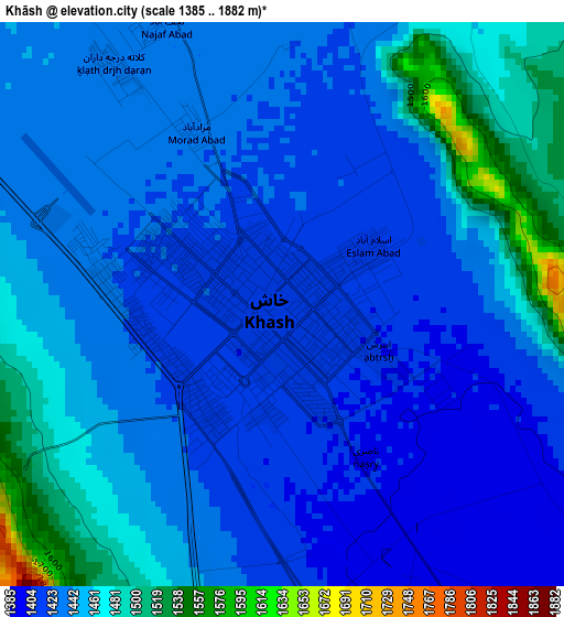
Below is the Elevation map of Khāsh, which displays elevation range with different colors. Scale of the first map is from 1385 to 1882 m (4544 to 6175 ft) with average elevation of 1441.8 meters (=4730 ft) [note 1]
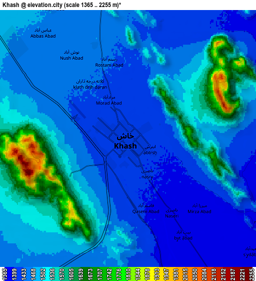
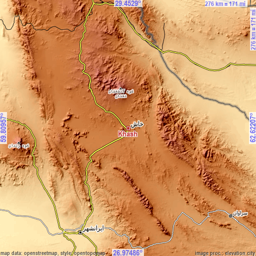
These maps also provides idea of topography and contour of this city, they are displayed at different zoom levels. More info about maps, scale and edge coordinates you can find below images.
| \ | Map #1 | Map #2 | Topo.Map |
| Scale [m] | 1385..1882 m | 1365..2255 m | × |
| Scale [ft] | 4544..6175 ft | 4478..7398 ft | × |
| Average | 1441.8 m = 4730 ft | 1484.5 m = 4870 ft | × |
| Width | 8.61 km = 5.3 mi | 17.22 km = 10.7 mi | 275.5 km = 171.2 mi |
| Height | 8.61 km = 5.3 mi | 17.22 km = 10.7 mi | 275.5 km = 171.2 mi |
| ↑Max Latitude | 28.259784° | 28.298485° | 29.4529° |
| Latitude at center | 28.22107° | 28.22107° | 28.22107° |
| ↓Min Latitude | 28.182341° | 28.143599° | 26.97486° |
| ← Min Longitude | 61.171875° | 61.127929° | 59.80957° |
| Longitude center | 61.21582° | 61.21582° | 61.21582° |
| →Max Longitude | 61.259765° | 61.303711° | 62.62207° |
Nearby cities:
Cities around Khāsh sort by population:
• Zahedan elevation 1380 m
145.9 km,  346°
346°
• Iranshahr 566 m
124.7 km,  204°
204°
• Qaşr-e Qand 516 m
224.1 km,  191°
191°
• Nīkshahr 466 m
242.9 km, 204°
• Fannūj 718 m
240.1 km,  220°
220°
• Noşratābād 1112 m
221.8 km,  327°
327°
• Fahraj 680 m
241.6 km,  289°
289°
• Rāsak 405 m
221.4 km,  175°
175°
• Moḩammadābād 602 m
215.3 km,  283°
283°
• Dalgān 388 m
192.4 km,  244°
244°
• Zābolī 1274 m
129.3 km,  159°
159°
• Sūrān 1151 m
129.3 km,  143°
143°
Multilingual:
 En español:
Khāsh elevación 1413 m.
 En France:
Khāsh élévation 1413 m.


Sources and notes:
- [note 1] Map square and city borders are not equal. Map elevation data is calculated only from area inside that square.
- [src 1] Elevation data from geonames database provided with same terms of usage.
- [src 2] The elevation map of Khāsh is generated using elevation data from NASA's 3 arcsec (90m) resolution SRTM data.
- [src 3] Base (background) map © OpenStreetMap contributors tiles are generated by Geofabrik and OpenTopoMap.
Copyright & License:
This Khāsh Elevation Map is licensed under CC BY-SA. You may reuse any part from this page, if you give a proper credit by linking to this URL:
 More info on terms of use page.