Iranshahr elevation
Iranshahr (Sistan and Baluchestan), Iran elevation is 566 meters and Iranshahr elevation in feet is 1857 ft above sea level [src 1]. Iranshahr is a seat of a second-order administrative division (feature code) with elevation that is 478 meters (1568 ft) smaller than average city elevation in Iran.
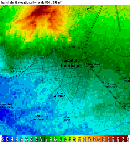
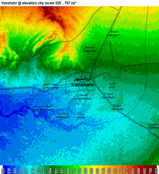
Below is the Elevation map of Iranshahr, which displays elevation range with different colors. Scale of the first map is from 534 to 659 m (1752 to 2162 ft) with average elevation of 573.9 meters (=1883 ft) [note 1]
These maps also provides idea of topography and contour of this city, they are displayed at different zoom levels. More info about maps, scale and edge coordinates you can find below images.
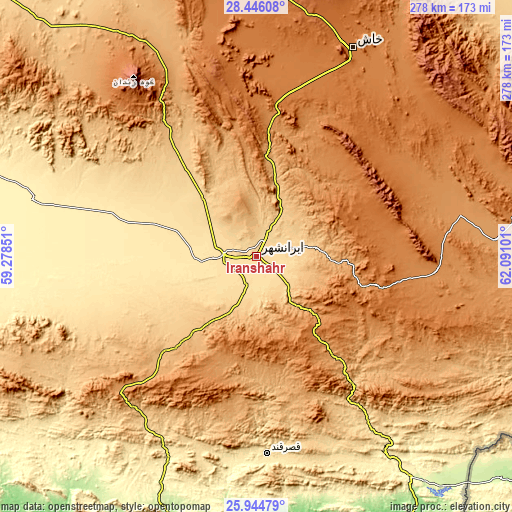
| \ | Map #1 | Map #2 | Topo.Map |
| Scale [m] | 534..659 m | 529..707 m | × |
| Scale [ft] | 1752..2162 ft | 1736..2320 ft | × |
| Average | 573.9 m = 1883 ft | 584.5 m = 1918 ft | × |
| Width | 8.69 km = 5.4 mi | 17.38 km = 10.8 mi | 278.1 km = 172.8 mi |
| Height | 8.69 km = 5.4 mi | 17.38 km = 10.8 mi | 278.1 km = 172.8 mi |
| ↑Max Latitude | 27.241528° | 27.280592° | 28.44608° |
| Latitude at center | 27.20245° | 27.20245° | 27.20245° |
| ↓Min Latitude | 27.163358° | 27.124253° | 25.94479° |
| ← Min Longitude | 60.640815° | 60.596869° | 59.27851° |
| Longitude center | 60.68476° | 60.68476° | 60.68476° |
| →Max Longitude | 60.728705° | 60.772651° | 62.09101° |
Nearby cities:
Cities around Iranshahr sort by population:
• Zahedan elevation 1380 m
255.6 km,  3°
3°
• Khāsh 1413 m
124.7 km,  24°
24°
• Chabahar 18 m
212.5 km,  181°
181°
• Qaşr-e Qand 516 m
106.3 km, 176°
• Nīkshahr 466 m
118.2 km,  203°
203°
• Fannūj 718 m
124.9 km,  236°
236°
• Moḩammadābād 602 m
227.2 km,  315°
315°
• Konārak 6 m
206.8 km,  187°
187°
• Sūrān 1151 m
130 km,  85°
85°
• Rāsak 405 m
128.7 km,  146°
146°
• Dalgān 388 m
126.2 km,  284°
284°
• Zābolī 1274 m
98.2 km, 94°
Multilingual:
 En español:
Iranshahr elevación 566 m.
 En France:
Iranshahr élévation 566 m.
 Auf Deutsch:
Iranshahr höhe über dem Meeresspiegel ist 566 m.

Sources and notes:
- [note 1] Map square and city borders are not equal. Map elevation data is calculated only from area inside that square.
- [src 1] Elevation data from geonames database provided with same terms of usage.
- [src 2] The elevation map of Iranshahr is generated using elevation data from NASA's 3 arcsec (90m) resolution SRTM data.
- [src 3] Base (background) map © OpenStreetMap contributors tiles are generated by Geofabrik and OpenTopoMap.
Copyright & License:
This Iranshahr Elevation Map is licensed under CC BY-SA. You may reuse any part from this page, if you give a proper credit by linking to this URL:
 More info on terms of use page.