Bam elevation
Bam (Kerman), Iran elevation is 1061 meters and Bam elevation in feet is 3481 ft above sea level [src 1]. Bam is a seat of a second-order administrative division (feature code) with elevation that is 17 meters (56 ft) bigger than average city elevation in Iran.
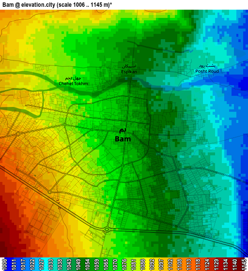
Below is the Elevation map of Bam, which displays elevation range with different colors. Scale of the first map is from 1006 to 1145 m (3301 to 3757 ft) with average elevation of 1065.5 meters (=3496 ft) [note 1]
These maps also provides idea of topography and contour of this city, they are displayed at different zoom levels. More info about maps, scale and edge coordinates you can find below images.
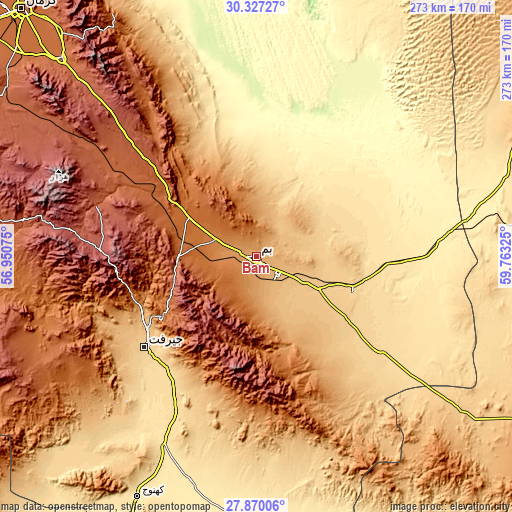
| \ | Map #1 | Map #2 | Topo.Map |
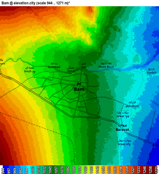
| Scale [m] | 1006..1145 m | 944..1271 m | × |
| Scale [ft] | 3301..3757 ft | 3097..4170 ft | × |
| Average | 1065.5 m = 3496 ft | 1081.2 m = 3547 ft | × |
| Width | 8.54 km = 5.3 mi | 17.08 km = 10.6 mi | 273.2 km = 169.8 mi |
| Height | 8.54 km = 5.3 mi | 17.08 km = 10.6 mi | 273.2 km = 169.8 mi |
| ↑Max Latitude | 29.144389° | 29.182763° | 30.32727° |
| Latitude at center | 29.106° | 29.106° | 29.106° |
| ↓Min Latitude | 29.067597° | 29.029179° | 27.87006° |
| ← Min Longitude | 58.313055° | 58.269109° | 56.95075° |
| Longitude center | 58.357° | 58.357° | 58.357° |
| →Max Longitude | 58.400945° | 58.444891° | 59.76325° |
Nearby cities:
Cities around Bam sort by population:
• Kerman elevation 1760 m
179.9 km,  316°
316°
• Kūh Sefīd 2564 m
152.2 km,  277°
277°
• Bāft 2268 m
171 km,  274°
274°
• Fāryāb 660 m
156.9 km,  224°
224°
• Kahnūj 505 m
143.5 km,  206°
206°
• Rābor 2331 m
141.7 km, 278°
• Eslāmābād 487 m
125 km,  196°
196°
• ‘Anbarābād 603 m
85.8 km, 215°
• Moḩammadābād 602 m
85 km,  124°
124°
• Jīroft 680 m
76.6 km,  231°
231°
• Fahraj 680 m
54.2 km,  108°
108°
• Narmāshīr 759 m
37.3 km, 117°
Multilingual:
 En español:
Bam elevación 1061 m.
 En France:
Bam élévation 1061 m.


Sources and notes:
- [note 1] Map square and city borders are not equal. Map elevation data is calculated only from area inside that square.
- [src 1] Elevation data from geonames database provided with same terms of usage.
- [src 2] The elevation map of Bam is generated using elevation data from NASA's 3 arcsec (90m) resolution SRTM data.
- [src 3] Base (background) map © OpenStreetMap contributors tiles are generated by Geofabrik and OpenTopoMap.
Copyright & License:
This Bam Elevation Map is licensed under CC BY-SA. You may reuse any part from this page, if you give a proper credit by linking to this URL:
 More info on terms of use page.