Vasīān elevation
Vasīān (Lorestān), Iran elevation is 991 meters and Vasīān elevation in feet is 3251 ft above sea level [src 1]. Vasīān is a populated place (feature code) with elevation that is 53 meters (174 ft) smaller than average city elevation in Iran.
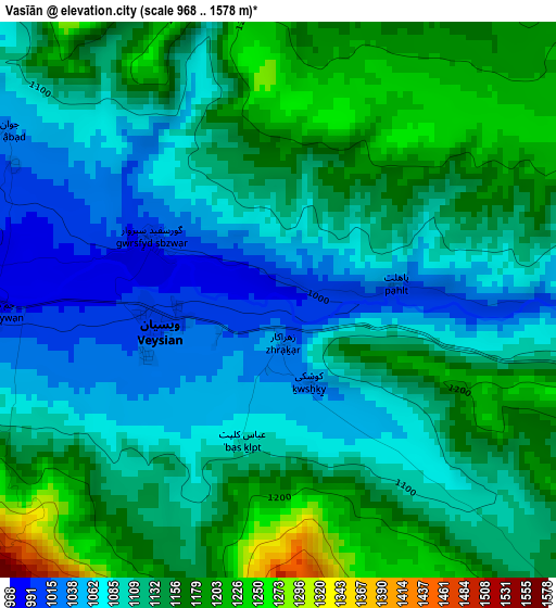
Below is the Elevation map of Vasīān, which displays elevation range with different colors. Scale of the first map is from 968 to 1578 m (3176 to 5177 ft) with average elevation of 1121.2 meters (=3678 ft) [note 1]
These maps also provides idea of topography and contour of this city, they are displayed at different zoom levels. More info about maps, scale and edge coordinates you can find below images.
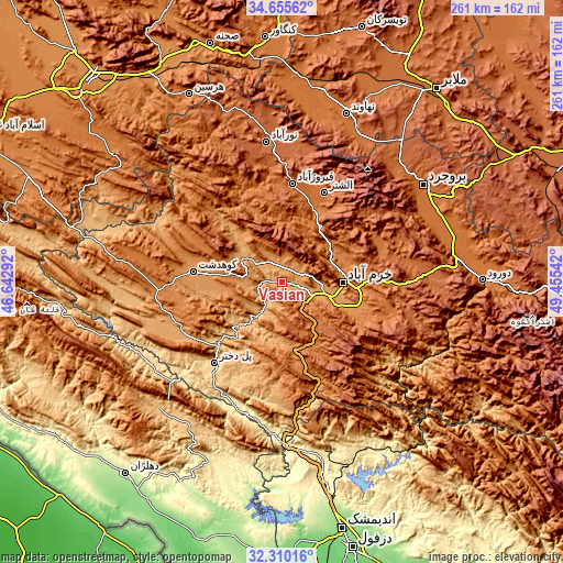
| \ | Map #1 | Topo.Map |
| Scale [m] | 968..1578 m | × |
| Scale [ft] | 3176..5177 ft | × |
| Average | 1121.2 m = 3678 ft | × |
| Width | 8.15 km = 5.1 mi | 260.8 km = 162.1 mi |
| Height | 8.15 km = 5.1 mi | 260.8 km = 162.1 mi |
| ↑Max Latitude | 33.527471° | 34.65562° |
| Latitude at center | 33.49083° | 33.49083° |
| ↓Min Latitude | 33.454173° | 32.31016° |
| ← Min Longitude | 48.005225° | 46.64292° |
| Longitude center | 48.04917° | 48.04917° |
| →Max Longitude | 48.093115° | 49.45542° |
Nearby cities:
Cities around Vasīān sort by population:
• Khorramabad elevation 1182 m
28.4 km,  90°
90°
• Borūjerd 1574 m
79.2 km,  55°
55°
• Kūhdasht 1190 m
41 km,  276°
276°
• Nūrābād 1790 m
65.2 km,  353°
353°
• Aznā 1494 m
82.7 km,  80°
80°
• Aleshtar 1614 m
46 km,  25°
25°
• Darreh Shahr 660 m
73.1 km,  238°
238°
• Ābdānān 889 m
80.6 km,  226°
226°
• Famast 1831 m
71.9 km, 32°
• pamas 1835 m
71.8 km, 32°
• Poldokhtar 663 m
49.1 km,  219°
219°
• Sarāb-e Dūreh 1114 m
8.5 km,  342°
342°
Multilingual:
 En español:
Vasīān elevación 991 m.
 En France:
Vasīān élévation 991 m.


Sources and notes:
- [note 1] Map square and city borders are not equal. Map elevation data is calculated only from area inside that square.
- [src 1] Elevation data from geonames database provided with same terms of usage.
- [src 2] The elevation map of Vasīān is generated using elevation data from NASA's 3 arcsec (90m) resolution SRTM data.
- [src 3] Base (background) map © OpenStreetMap contributors tiles are generated by Geofabrik and OpenTopoMap.
Copyright & License:
This Vasīān Elevation Map is licensed under CC BY-SA. You may reuse any part from this page, if you give a proper credit by linking to this URL:
 More info on terms of use page.