Ābdānān elevation
Ābdānān (Ilam Province), Iran elevation is 889 meters and Ābdānān elevation in feet is 2917 ft above sea level [src 1]. Ābdānān is a seat of a second-order administrative division (feature code) with elevation that is 155 meters (509 ft) smaller than average city elevation in Iran.
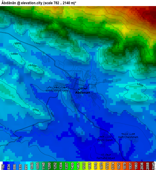
Below is the Elevation map of Ābdānān, which displays elevation range with different colors. Scale of the first map is from 782 to 2140 m (2566 to 7021 ft) with average elevation of 1044.3 meters (=3426 ft) [note 1]
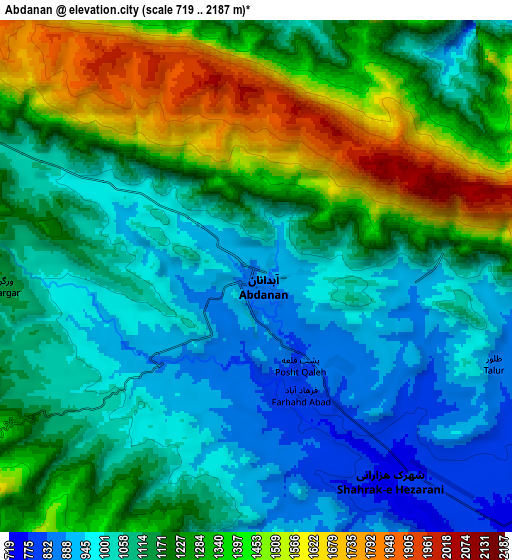
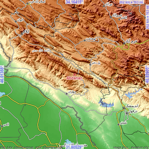
These maps also provides idea of topography and contour of this city, they are displayed at different zoom levels. More info about maps, scale and edge coordinates you can find below images.
| \ | Map #1 | Map #2 | Topo.Map |
| Scale [m] | 782..2140 m | 719..2187 m | × |
| Scale [ft] | 2566..7021 ft | 2359..7175 ft | × |
| Average | 1044.3 m = 3426 ft | 1178.6 m = 3867 ft | × |
| Width | 8.2 km = 5.1 mi | 16.39 km = 10.2 mi | 262.3 km = 163 mi |
| Height | 8.2 km = 5.1 mi | 16.39 km = 10.2 mi | 262.3 km = 163 mi |
| ↑Max Latitude | 33.029451° | 33.066287° | 34.16415° |
| Latitude at center | 32.9926° | 32.9926° | 32.9926° |
| ↓Min Latitude | 32.955734° | 32.918852° | 31.80529° |
| ← Min Longitude | 47.375855° | 47.331909° | 46.01355° |
| Longitude center | 47.4198° | 47.4198° | 47.4198° |
| →Max Longitude | 47.463745° | 47.507691° | 48.82605° |
Nearby cities:
Cities around Ābdānān sort by population:
• Khorramabad elevation 1182 m
103 km,  57°
57°
• Īlām 1403 m
117.1 km,  307°
307°
• Kūhdasht 1190 m
62.7 km,  16°
16°
• Dehlorān 224 m
36.1 km,  203°
203°
• Darreh Shahr 660 m
17.3 km,  347°
347°
• Vasīān 991 m
80.6 km,  46°
46°
• Sarābleh 1027 m
117.1 km,  317°
317°
• Dezful 143 m
114.6 km,  126°
126°
• Andīmeshk 147 m
105.4 km,  124°
124°
• Arakvāz-e Malekshāhī 1326 m
87.9 km,  299°
299°
• Sarāb-e Dūreh 1114 m
84.7 km,  41°
41°
• Poldokhtar 663 m
32.4 km, 56°
Multilingual:
 En español:
Ābdānān elevación 889 m.
 En France:
Ābdānān élévation 889 m.


Sources and notes:
- [note 1] Map square and city borders are not equal. Map elevation data is calculated only from area inside that square.
- [src 1] Elevation data from geonames database provided with same terms of usage.
- [src 2] The elevation map of Ābdānān is generated using elevation data from NASA's 3 arcsec (90m) resolution SRTM data.
- [src 3] Base (background) map © OpenStreetMap contributors tiles are generated by Geofabrik and OpenTopoMap.
Copyright & License:
This Ābdānān Elevation Map is licensed under CC BY-SA. You may reuse any part from this page, if you give a proper credit by linking to this URL:
 More info on terms of use page.