Borūjerd elevation
Borūjerd (Lorestān), Iran elevation is 1574 meters and Borūjerd elevation in feet is 5164 ft above sea level [src 1]. Borūjerd is a seat of a second-order administrative division (feature code) with elevation that is 530 meters (1739 ft) bigger than average city elevation in Iran.
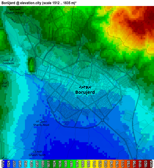
Below is the Elevation map of Borūjerd, which displays elevation range with different colors. Scale of the first map is from 1512 to 1835 m (4961 to 6020 ft) with average elevation of 1592.7 meters (=5225 ft) [note 1]
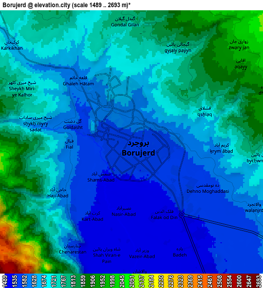
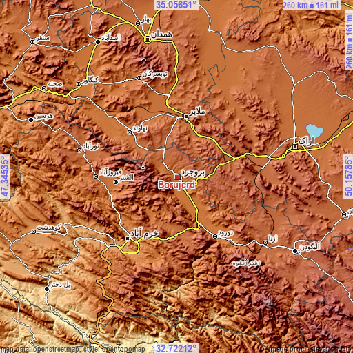
These maps also provides idea of topography and contour of this city, they are displayed at different zoom levels. More info about maps, scale and edge coordinates you can find below images.
| \ | Map #1 | Map #2 | Topo.Map |
| Scale [m] | 1512..1835 m | 1489..2693 m | × |
| Scale [ft] | 4961..6020 ft | 4885..8835 ft | × |
| Average | 1592.7 m = 5225 ft | 1695.3 m = 5562 ft | × |
| Width | 8.11 km = 5 mi | 16.22 km = 10.1 mi | 259.6 km = 161.3 mi |
| Height | 8.11 km = 5 mi | 16.22 km = 10.1 mi | 259.6 km = 161.3 mi |
| ↑Max Latitude | 33.933769° | 33.970221° | 35.05651° |
| Latitude at center | 33.8973° | 33.8973° | 33.8973° |
| ↓Min Latitude | 33.860816° | 33.824316° | 32.72212° |
| ← Min Longitude | 48.707655° | 48.663709° | 47.34535° |
| Longitude center | 48.7516° | 48.7516° | 48.7516° |
| →Max Longitude | 48.795545° | 48.839491° | 50.15785° |
Nearby cities:
Cities around Borūjerd sort by population:
• Khorramabad elevation 1182 m
58.4 km,  218°
218°
• Malāyer 1760 m
45.4 km,  8°
8°
• Nahāvand 1673 m
47.7 km,  313°
313°
• Nūrābād 1790 m
74.5 km,  285°
285°
• Aznā 1494 m
36 km,  152°
152°
• Aleshtar 1614 m
45.3 km,  265°
265°
• Anūch 1935 m
28.6 km,  325°
325°
• Famast 1831 m
31 km,  300°
300°
• pamas 1835 m
30.9 km, 300°
• Khondāb 1695 m
68 km,  35°
35°
• Shāzand 1906 m
60.5 km,  86°
86°
• Dorūd 1454 m
53.4 km, 147°
Multilingual:
 En español:
Borūjerd elevación 1574 m.
 En France:
Borūjerd élévation 1574 m.
 Auf Deutsch:
Borūjerd höhe über dem Meeresspiegel ist 1574 m.

Sources and notes:
- [note 1] Map square and city borders are not equal. Map elevation data is calculated only from area inside that square.
- [src 1] Elevation data from geonames database provided with same terms of usage.
- [src 2] The elevation map of Borūjerd is generated using elevation data from NASA's 3 arcsec (90m) resolution SRTM data.
- [src 3] Base (background) map © OpenStreetMap contributors tiles are generated by Geofabrik and OpenTopoMap.
Copyright & License:
This Borūjerd Elevation Map is licensed under CC BY-SA. You may reuse any part from this page, if you give a proper credit by linking to this URL:
 More info on terms of use page.