Abohar elevation
Abohar (Punjab, Firozpur), India elevation is 187 meters and Abohar elevation in feet is 614 ft above sea level [src 1]. Abohar is a populated place (feature code) with elevation that is 106 meters (348 ft) smaller than average city elevation in India.
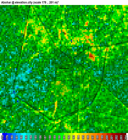
Below is the Elevation map of Abohar, which displays elevation range with different colors. Scale of the first map is from 178 to 201 m (584 to 659 ft) with average elevation of 187.4 meters (=615 ft) [note 1]
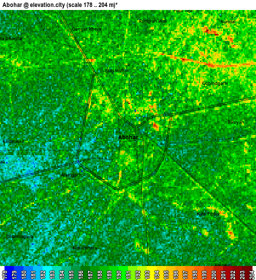
These maps also provides idea of topography and contour of this city, they are displayed at different zoom levels. More info about maps, scale and edge coordinates you can find below images.
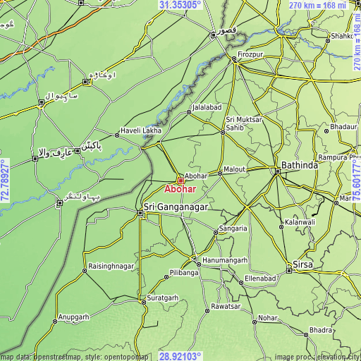
| \ | Map #1 | Map #2 | Topo.Map |
| Scale [m] | 178..201 m | 178..204 m | × |
| Scale [ft] | 584..659 ft | 584..669 ft | × |
| Average | 187.4 m = 615 ft | 187.2 m = 614 ft | × |
| Width | 8.45 km = 5.3 mi | 16.9 km = 10.5 mi | 270.4 km = 168 mi |
| Height | 8.45 km = 5.3 mi | 16.9 km = 10.5 mi | 270.4 km = 168 mi |
| ↑Max Latitude | 30.182525° | 30.220505° | 31.35305° |
| Latitude at center | 30.14453° | 30.14453° | 30.14453° |
| ↓Min Latitude | 30.10652° | 30.068496° | 28.92103° |
| ← Min Longitude | 74.151575° | 74.107629° | 72.78927° |
| Longitude center | 74.19552° | 74.19552° | 74.19552° |
| →Max Longitude | 74.239465° | 74.283411° | 75.60177° |
Nearby cities:
Cities around Abohar sort by population:
• Bathinda elevation 216 m
71.8 km,  84°
84°
• Gangānagar 176 m
39.7 km,  231°
231°
• Hanumāngarh 184 m
63.9 km,  168°
168°
• Muktsar 200 m
47.9 km,  40°
40°
• Malaut 195 m
28.5 km,  74°
74°
• Fāzilka 181 m
32.8 km,  330°
330°
• Dabwāli 198 m
56.6 km,  112°
112°
• Giddarbāha 199 m
45.7 km, 82°
• Sangariā 192 m
46.5 km,  145°
145°
• Jalālābād 189 m
51.7 km,  6°
6°
• Padampur 170 m
73.2 km, 228°
• Guru Har Sahāi 191 m
65.8 km,  17°
17°
Multilingual:
 En español:
Abohar elevación 187 m.
 En France:
Abohar élévation 187 m.


Sources and notes:
- [note 1] Map square and city borders are not equal. Map elevation data is calculated only from area inside that square.
- [src 1] Elevation data from geonames database provided with same terms of usage.
- [src 2] The elevation map of Abohar is generated using elevation data from NASA's 3 arcsec (90m) resolution SRTM data.
- [src 3] Base (background) map © OpenStreetMap contributors tiles are generated by Geofabrik and OpenTopoMap.
Copyright & License:
This Abohar Elevation Map is licensed under CC BY-SA. You may reuse any part from this page, if you give a proper credit by linking to this URL:
 More info on terms of use page.