Bathinda elevation
Bathinda (Punjab), India elevation is 216 meters and Bathinda elevation in feet is 709 ft above sea level [src 1]. Bathinda is a populated place (feature code) with elevation that is 77 meters (253 ft) smaller than average city elevation in India.
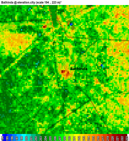
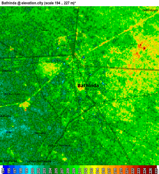
Below is the Elevation map of Bathinda, which displays elevation range with different colors. Scale of the first map is from 194 to 223 m (636 to 732 ft) with average elevation of 207.8 meters (=682 ft) [note 1]
These maps also provides idea of topography and contour of this city, they are displayed at different zoom levels. More info about maps, scale and edge coordinates you can find below images.
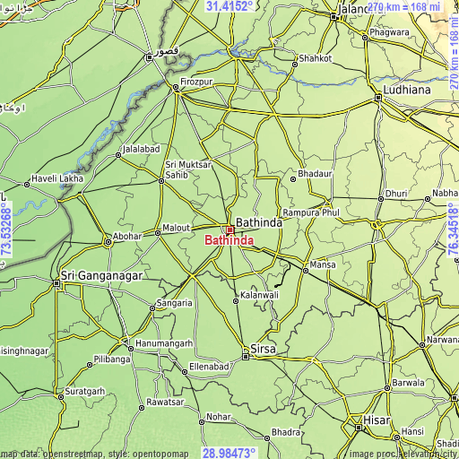
| \ | Map #1 | Map #2 | Topo.Map |
| Scale [m] | 194..223 m | 194..227 m | × |
| Scale [ft] | 636..732 ft | 636..745 ft | × |
| Average | 207.8 m = 682 ft | 207.6 m = 681 ft | × |
| Width | 8.45 km = 5.3 mi | 16.89 km = 10.5 mi | 270.2 km = 167.9 mi |
| Height | 8.45 km = 5.3 mi | 16.89 km = 10.5 mi | 270.2 km = 167.9 mi |
| ↑Max Latitude | 30.245441° | 30.283397° | 31.4152° |
| Latitude at center | 30.20747° | 30.20747° | 30.20747° |
| ↓Min Latitude | 30.169485° | 30.131485° | 28.98473° |
| ← Min Longitude | 74.894985° | 74.851039° | 73.53268° |
| Longitude center | 74.93893° | 74.93893° | 74.93893° |
| →Max Longitude | 74.982875° | 75.026821° | 76.34518° |
Nearby cities:
Cities around Bathinda sort by population:
• Muktsar elevation 200 m
50.2 km,  306°
306°
• Kotkapura 208 m
42.9 km,  346°
346°
• Mānsa 223 m
50.7 km,  118°
118°
• Farīdkot 207 m
54.8 km,  341°
341°
• Malaut 195 m
43.9 km,  270°
270°
• Dabwāli 198 m
34.6 km,  213°
213°
• Rāmpura 218 m
29.5 km,  79°
79°
• Giddarbāha 199 m
26.2 km, 268°
• Jaito 211 m
27.5 km, 350°
• Maur 220 m
32.9 km,  114°
114°
• Kālānwāli 204 m
41.5 km,  175°
175°
• Bhadaur 230 m
48 km,  51°
51°
Multilingual:
 En español:
Bathinda elevación 216 m.
 En France:
Bathinda élévation 216 m.
 Auf Deutsch:
Bathinda höhe über dem Meeresspiegel ist 216 m.

Sources and notes:
- [note 1] Map square and city borders are not equal. Map elevation data is calculated only from area inside that square.
- [src 1] Elevation data from geonames database provided with same terms of usage.
- [src 2] The elevation map of Bathinda is generated using elevation data from NASA's 3 arcsec (90m) resolution SRTM data.
- [src 3] Base (background) map © OpenStreetMap contributors tiles are generated by Geofabrik and OpenTopoMap.
Copyright & License:
This Bathinda Elevation Map is licensed under CC BY-SA. You may reuse any part from this page, if you give a proper credit by linking to this URL:
 More info on terms of use page.