Sangariā elevation
Sangariā (Rajasthan, Hanumangarh), India elevation is 192 meters and Sangariā elevation in feet is 630 ft above sea level [src 1]. Sangariā is a populated place (feature code) with elevation that is 101 meters (331 ft) smaller than average city elevation in India.
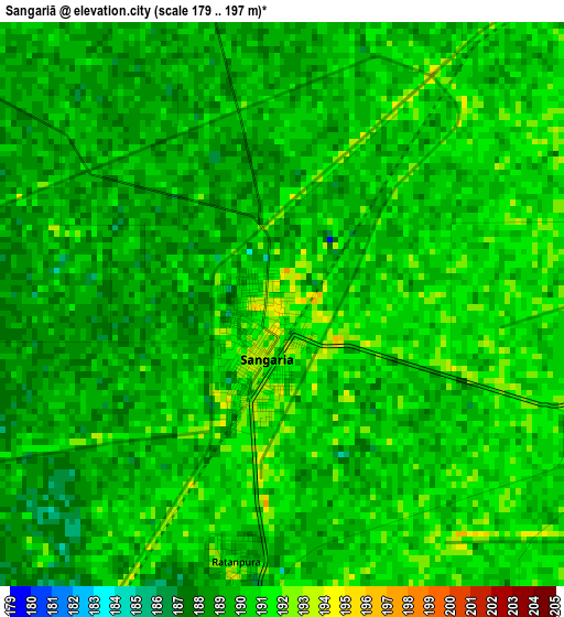
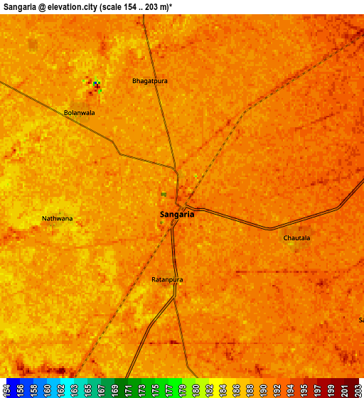
Below is the Elevation map of Sangariā, which displays elevation range with different colors. Scale of the first map is from 179 to 197 m (587 to 646 ft) with average elevation of 189.4 meters (=621 ft) [note 1]
These maps also provides idea of topography and contour of this city, they are displayed at different zoom levels. More info about maps, scale and edge coordinates you can find below images.
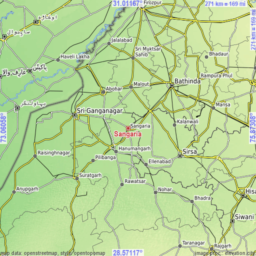
| \ | Map #1 | Map #2 | Topo.Map |
| Scale [m] | 179..197 m | 154..203 m | × |
| Scale [ft] | 587..646 ft | 505..666 ft | × |
| Average | 189.4 m = 621 ft | 189.5 m = 622 ft | × |
| Width | 8.48 km = 5.3 mi | 16.96 km = 10.5 mi | 271.4 km = 168.6 mi |
| Height | 8.48 km = 5.3 mi | 16.96 km = 10.5 mi | 271.4 km = 168.6 mi |
| ↑Max Latitude | 29.836987° | 29.8751° | 31.01167° |
| Latitude at center | 29.79886° | 29.79886° | 29.79886° |
| ↓Min Latitude | 29.760718° | 29.722562° | 28.57117° |
| ← Min Longitude | 74.422885° | 74.378939° | 73.06058° |
| Longitude center | 74.46683° | 74.46683° | 74.46683° |
| →Max Longitude | 74.510775° | 74.554721° | 75.87308° |
Nearby cities:
Cities around Sangariā sort by population:
• Gangānagar elevation 176 m
58.6 km,  283°
283°
• Sirsa 205 m
61.7 km,  118°
118°
• Hanumāngarh 184 m
27.5 km,  208°
208°
• Abohar 187 m
46.5 km,  325°
325°
• Malaut 195 m
45.9 km,  1°
1°
• Dabwāli 198 m
31 km,  57°
57°
• Giddarbāha 199 m
48.5 km,  23°
23°
• Ellenabad 196 m
42.8 km,  153°
153°
• Pilibangan 179 m
52.5 km,  222°
222°
• Rāwatsār 182 m
59.4 km,  185°
185°
• Kālānwāli 204 m
48.9 km,  85°
85°
• Rānia 203 m
47 km,  130°
130°
Multilingual:
 En español:
Sangariā elevación 192 m.
 En France:
Sangariā élévation 192 m.
 Auf Deutsch:
Sangariā höhe über dem Meeresspiegel ist 192 m.

Sources and notes:
- [note 1] Map square and city borders are not equal. Map elevation data is calculated only from area inside that square.
- [src 1] Elevation data from geonames database provided with same terms of usage.
- [src 2] The elevation map of Sangariā is generated using elevation data from NASA's 3 arcsec (90m) resolution SRTM data.
- [src 3] Base (background) map © OpenStreetMap contributors tiles are generated by Geofabrik and OpenTopoMap.
Copyright & License:
This Sangariā Elevation Map is licensed under CC BY-SA. You may reuse any part from this page, if you give a proper credit by linking to this URL:
 More info on terms of use page.