Akot elevation
Akot (Maharashtra, Akola), India elevation is 311 meters and Akot elevation in feet is 1020 ft above sea level [src 1]. Akot is a populated place (feature code) with elevation that is 18 meters (59 ft) bigger than average city elevation in India.
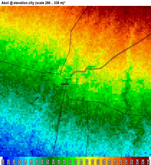
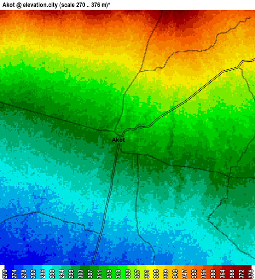
Below is the Elevation map of Akot, which displays elevation range with different colors. Scale of the first map is from 286 to 338 m (938 to 1109 ft) with average elevation of 309.4 meters (=1015 ft) [note 1]
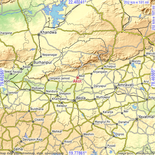
These maps also provides idea of topography and contour of this city, they are displayed at different zoom levels. More info about maps, scale and edge coordinates you can find below images.
| \ | Map #1 | Map #2 | Topo.Map |
| Scale [m] | 286..338 m | 270..376 m | × |
| Scale [ft] | 938..1109 ft | 886..1234 ft | × |
| Average | 309.4 m = 1015 ft | 311.2 m = 1021 ft | × |
| Width | 9.12 km = 5.7 mi | 18.24 km = 11.3 mi | 291.7 km = 181.3 mi |
| Height | 9.12 km = 5.7 mi | 18.24 km = 11.3 mi | 291.8 km = 181.3 mi |
| ↑Max Latitude | 21.137294° | 21.178277° | 22.40241° |
| Latitude at center | 21.0963° | 21.0963° | 21.0963° |
| ↓Min Latitude | 21.055294° | 21.014277° | 19.77861° |
| ← Min Longitude | 77.014855° | 76.970909° | 75.65255° |
| Longitude center | 77.0588° | 77.0588° | 77.0588° |
| →Max Longitude | 77.102745° | 77.146691° | 78.46505° |
Nearby cities:
Cities around Akot sort by population:
• Akola elevation 285 m
43.5 km,  188°
188°
• Achalpur 376 m
50.1 km,  69°
69°
• Khāmgaon 304 m
66.8 km,  229°
229°
• Shegaon 275 m
50.3 km, 227°
• Anjangaon 344 m
27.1 km, 73°
• Bālāpur 277 m
56.3 km,  211°
211°
• Murtajāpur 303 m
51.5 km,  141°
141°
• Nāndūra Buzurg 271 m
68.7 km,  244°
244°
• Daryāpur 287 m
33.7 km,  124°
124°
• Jalgaon Jamod 309 m
54.6 km,  264°
264°
• Pātūr 348 m
71.8 km, 190°
• Telhāra 286 m
24.1 km,  251°
251°
Multilingual:
 En español:
Akot elevación 311 m.
 En France:
Akot élévation 311 m.


Sources and notes:
- [note 1] Map square and city borders are not equal. Map elevation data is calculated only from area inside that square.
- [src 1] Elevation data from geonames database provided with same terms of usage.
- [src 2] The elevation map of Akot is generated using elevation data from NASA's 3 arcsec (90m) resolution SRTM data.
- [src 3] Base (background) map © OpenStreetMap contributors tiles are generated by Geofabrik and OpenTopoMap.
Copyright & License:
This Akot Elevation Map is licensed under CC BY-SA. You may reuse any part from this page, if you give a proper credit by linking to this URL:
 More info on terms of use page.