Khāmgaon elevation
Khāmgaon (Maharashtra, Buldana), India elevation is 304 meters and Khāmgaon elevation in feet is 997 ft above sea level [src 1]. Khāmgaon is a populated place (feature code) with elevation that is 11 meters (36 ft) bigger than average city elevation in India.
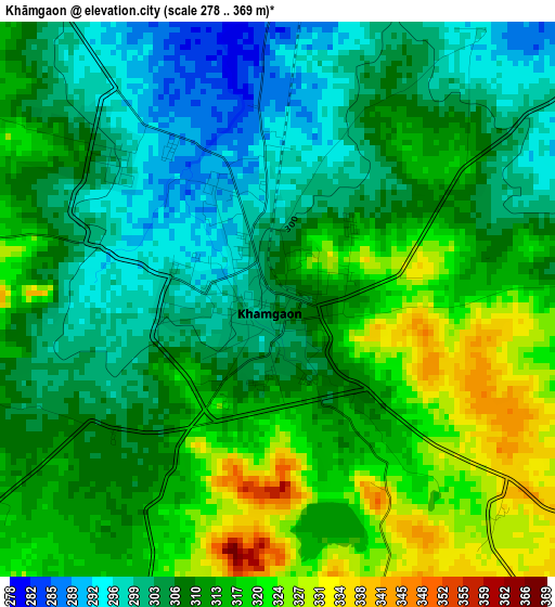
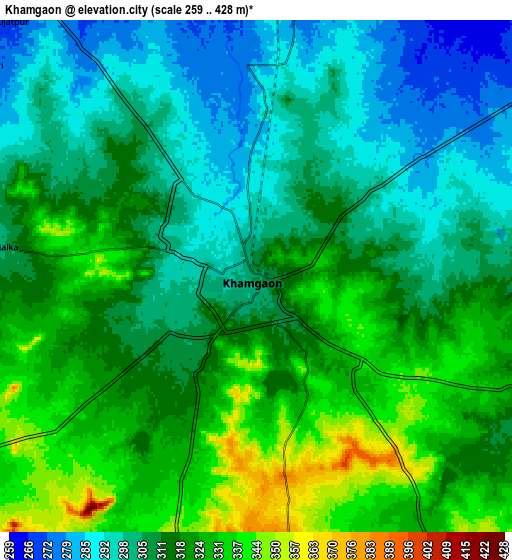
Below is the Elevation map of Khāmgaon, which displays elevation range with different colors. Scale of the first map is from 278 to 369 m (912 to 1211 ft) with average elevation of 309.9 meters (=1017 ft) [note 1]
These maps also provides idea of topography and contour of this city, they are displayed at different zoom levels. More info about maps, scale and edge coordinates you can find below images.
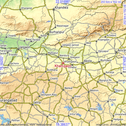
| \ | Map #1 | Map #2 | Topo.Map |
| Scale [m] | 278..369 m | 259..428 m | × |
| Scale [ft] | 912..1211 ft | 850..1404 ft | × |
| Average | 309.9 m = 1017 ft | 312.5 m = 1025 ft | × |
| Width | 9.14 km = 5.7 mi | 18.28 km = 11.4 mi | 292.5 km = 181.8 mi |
| Height | 9.14 km = 5.7 mi | 18.28 km = 11.4 mi | 292.5 km = 181.8 mi |
| ↑Max Latitude | 20.748481° | 20.78957° | 22.01698° |
| Latitude at center | 20.70738° | 20.70738° | 20.70738° |
| ↓Min Latitude | 20.666268° | 20.625145° | 19.38637° |
| ← Min Longitude | 76.524325° | 76.480379° | 75.16202° |
| Longitude center | 76.56827° | 76.56827° | 76.56827° |
| →Max Longitude | 76.612215° | 76.656161° | 77.97452° |
Nearby cities:
Cities around Khāmgaon sort by population:
• Akola elevation 285 m
44.7 km,  89°
89°
• Akot 311 m
66.8 km,  49°
49°
• Buldāna 654 m
44.6 km,  243°
243°
• Malkāpur 253 m
43.2 km,  297°
297°
• Shegaon 275 m
16.6 km, 54°
• Chikhli 601 m
51.2 km,  219°
219°
• Bālāpur 277 m
21.9 km,  102°
102°
• Mehekar 559 m
61.9 km,  179°
179°
• Nāndūra Buzurg 271 m
18.1 km,  321°
321°
• Jalgaon Jamod 309 m
38.5 km,  354°
354°
• Pātūr 348 m
47.2 km,  125°
125°
• Telhāra 286 m
45.3 km,  38°
38°
Multilingual:
 En español:
Khāmgaon elevación 304 m.
 En France:
Khāmgaon élévation 304 m.
 Auf Deutsch:
Khāmgaon höhe über dem Meeresspiegel ist 304 m.

Sources and notes:
- [note 1] Map square and city borders are not equal. Map elevation data is calculated only from area inside that square.
- [src 1] Elevation data from geonames database provided with same terms of usage.
- [src 2] The elevation map of Khāmgaon is generated using elevation data from NASA's 3 arcsec (90m) resolution SRTM data.
- [src 3] Base (background) map © OpenStreetMap contributors tiles are generated by Geofabrik and OpenTopoMap.
Copyright & License:
This Khāmgaon Elevation Map is licensed under CC BY-SA. You may reuse any part from this page, if you give a proper credit by linking to this URL:
 More info on terms of use page.