Murtajāpur elevation
Murtajāpur (Maharashtra, Akola), India elevation is 303 meters and Murtajāpur elevation in feet is 994 ft above sea level [src 1]. Murtajāpur is a populated place (feature code) with elevation that is 10 meters (33 ft) bigger than average city elevation in India.
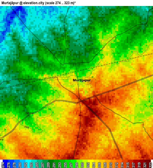
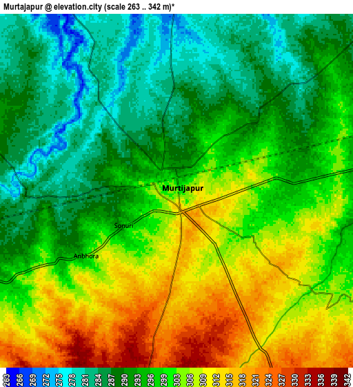
Below is the Elevation map of Murtajāpur, which displays elevation range with different colors. Scale of the first map is from 274 to 323 m (899 to 1060 ft) with average elevation of 299 meters (=981 ft) [note 1]
These maps also provides idea of topography and contour of this city, they are displayed at different zoom levels. More info about maps, scale and edge coordinates you can find below images.
| \ | Map #1 | Map #2 | Topo.Map |
| Scale [m] | 274..323 m | 263..342 m | × |
| Scale [ft] | 899..1060 ft | 863..1122 ft | × |
| Average | 299 m = 981 ft | 298.1 m = 978 ft | × |
| Width | 9.14 km = 5.7 mi | 18.28 km = 11.4 mi | 292.4 km = 181.7 mi |
| Height | 9.14 km = 5.7 mi | 18.28 km = 11.4 mi | 292.5 km = 181.8 mi |
| ↑Max Latitude | 20.774084° | 20.815167° | 22.04236° |
| Latitude at center | 20.73299° | 20.73299° | 20.73299° |
| ↓Min Latitude | 20.691885° | 20.650769° | 19.41219° |
| ← Min Longitude | 77.322995° | 77.279049° | 75.96069° |
| Longitude center | 77.36694° | 77.36694° | 77.36694° |
| →Max Longitude | 77.410885° | 77.454831° | 78.77319° |
Nearby cities:
Cities around Murtajāpur sort by population:
• Amrāvati elevation 341 m
45.6 km,  60°
60°
• Akola 285 m
38.4 km,  266°
266°
• Achalpur 376 m
60.1 km,  14°
14°
• Akot 311 m
51.5 km,  321°
321°
• Kāranja 414 m
30.6 km,  155°
155°
• Anjangaon 344 m
48.4 km,  352°
352°
• Bālāpur 277 m
62.1 km,  263°
263°
• Daryāpur 287 m
21.7 km, 348°
• Mangrūl Pīr 450 m
46.7 km,  183°
183°
• Dārwha 337 m
63.2 km,  138°
138°
• Pātūr 348 m
54 km,  235°
235°
• Telhāra 286 m
63.9 km,  300°
300°
Multilingual:
 En español:
Murtajāpur elevación 303 m.
 En France:
Murtajāpur élévation 303 m.
 Auf Deutsch:
Murtajāpur höhe über dem Meeresspiegel ist 303 m.

Sources and notes:
- [note 1] Map square and city borders are not equal. Map elevation data is calculated only from area inside that square.
- [src 1] Elevation data from geonames database provided with same terms of usage.
- [src 2] The elevation map of Murtajāpur is generated using elevation data from NASA's 3 arcsec (90m) resolution SRTM data.
- [src 3] Base (background) map © OpenStreetMap contributors tiles are generated by Geofabrik and OpenTopoMap.
Copyright & License:
This Murtajāpur Elevation Map is licensed under CC BY-SA. You may reuse any part from this page, if you give a proper credit by linking to this URL:
 More info on terms of use page.