Alnāvar elevation
Alnāvar (Karnataka, Dharwad), India elevation is 576 meters and Alnāvar elevation in feet is 1890 ft above sea level [src 1]. Alnāvar is a populated place (feature code) with elevation that is 283 meters (928 ft) bigger than average city elevation in India.
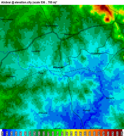
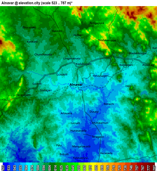
Below is the Elevation map of Alnāvar, which displays elevation range with different colors. Scale of the first map is from 536 to 705 m (1759 to 2313 ft) with average elevation of 577.5 meters (=1895 ft) [note 1]
These maps also provides idea of topography and contour of this city, they are displayed at different zoom levels. More info about maps, scale and edge coordinates you can find below images.
| \ | Map #1 | Map #2 | Topo.Map |
| Scale [m] | 536..705 m | 523..787 m | × |
| Scale [ft] | 1759..2313 ft | 1716..2582 ft | × |
| Average | 577.5 m = 1895 ft | 596.3 m = 1956 ft | × |
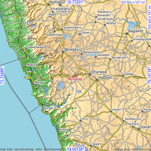
| Width | 9.42 km = 5.9 mi | 18.84 km = 11.7 mi | 301.4 km = 187.3 mi |
| Height | 9.42 km = 5.9 mi | 18.84 km = 11.7 mi | 301.5 km = 187.3 mi |
| ↑Max Latitude | 15.469628° | 15.511977° | 16.77831° |
| Latitude at center | 15.42727° | 15.42727° | 15.42727° |
| ↓Min Latitude | 15.384904° | 15.342529° | 14.06738° |
| ← Min Longitude | 74.697165° | 74.653219° | 73.33486° |
| Longitude center | 74.74111° | 74.74111° | 74.74111° |
| →Max Longitude | 74.785055° | 74.829001° | 76.14736° |
Nearby cities:
Cities around Alnāvar sort by population:
• Hubli elevation 620 m
43 km,  101°
101°
• Belgaum 769 m
53.6 km,  331°
331°
• Dandeli 474 m
22.3 km,  216°
216°
• Bail-Hongal 687 m
44.8 km,  16°
16°
• Saundatti 660 m
55.2 km,  46°
46°
• Haliyal 554 m
11.1 km,  171°
171°
• Yellāpur 559 m
51.7 km,  183°
183°
• Kundgol 645 m
57.5 km,  109°
109°
• Khānāpur 674 m
34.3 km,  313°
313°
• Mundgod 579 m
59.8 km,  147°
147°
• Kalghatgi 568 m
36.7 km,  137°
137°
• Londa 682 m
24.2 km,  281°
281°
Multilingual:
 En español:
Alnāvar elevación 576 m.
 En France:
Alnāvar élévation 576 m.


Sources and notes:
- [note 1] Map square and city borders are not equal. Map elevation data is calculated only from area inside that square.
- [src 1] Elevation data from geonames database provided with same terms of usage.
- [src 2] The elevation map of Alnāvar is generated using elevation data from NASA's 3 arcsec (90m) resolution SRTM data.
- [src 3] Base (background) map © OpenStreetMap contributors tiles are generated by Geofabrik and OpenTopoMap.
Copyright & License:
This Alnāvar Elevation Map is licensed under CC BY-SA. You may reuse any part from this page, if you give a proper credit by linking to this URL:
 More info on terms of use page.