Khānāpur elevation
Khānāpur (Karnataka, Belgaum), India elevation is 674 meters and Khānāpur elevation in feet is 2211 ft above sea level [src 1]. Khānāpur is a populated place (feature code) with elevation that is 381 meters (1250 ft) bigger than average city elevation in India.
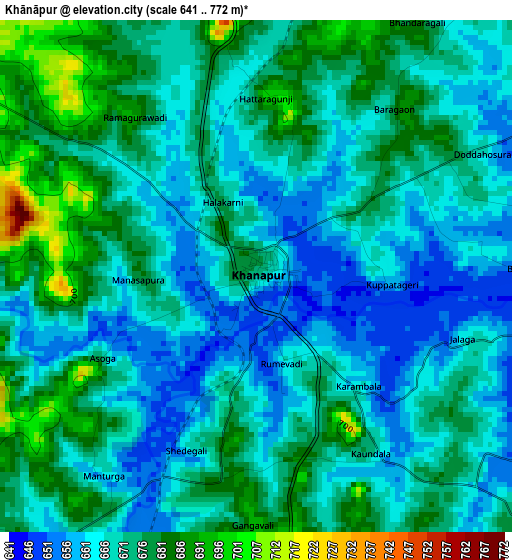
Below is the Elevation map of Khānāpur, which displays elevation range with different colors. Scale of the first map is from 641 to 772 m (2103 to 2533 ft) with average elevation of 671.2 meters (=2202 ft) [note 1]
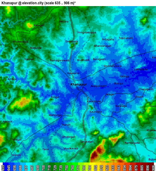
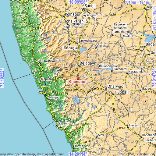
These maps also provides idea of topography and contour of this city, they are displayed at different zoom levels. More info about maps, scale and edge coordinates you can find below images.
| \ | Map #1 | Map #2 | Topo.Map |
| Scale [m] | 641..772 m | 635..906 m | × |
| Scale [ft] | 2103..2533 ft | 2083..2972 ft | × |
| Average | 671.2 m = 2202 ft | 690.6 m = 2266 ft | × |
| Width | 9.41 km = 5.8 mi | 18.82 km = 11.7 mi | 301.1 km = 187.1 mi |
| Height | 9.41 km = 5.8 mi | 18.82 km = 11.7 mi | 301.1 km = 187.1 mi |
| ↑Max Latitude | 15.682004° | 15.724309° | 16.98928° |
| Latitude at center | 15.63969° | 15.63969° | 15.63969° |
| ↓Min Latitude | 15.597367° | 15.555036° | 14.28114° |
| ← Min Longitude | 74.464525° | 74.420579° | 73.10222° |
| Longitude center | 74.50847° | 74.50847° | 74.50847° |
| →Max Longitude | 74.552415° | 74.596361° | 75.91472° |
Nearby cities:
Cities around Khānāpur sort by population:
• Belgaum elevation 769 m
23.6 km,  358°
358°
• Dandeli 474 m
43.1 km,  164°
164°
• Bail-Hongal 687 m
42.2 km,  62°
62°
• Haliyal 554 m
43.6 km,  142°
142°
• Alnāvar 576 m
34.3 km,  133°
133°
• Curti 51 m
58.2 km,  244°
244°
• Navelim 18 m
57.5 km,  258°
258°
• Sanquelim 17 m
54.3 km, 261°
• Valpoy 31 m
41.6 km,  253°
253°
• Londa 682 m
19 km,  176°
176°
• Carapur 37 m
56.4 km, 261°
• Palle 12 m
49.4 km, 247°
Multilingual:
 En español:
Khānāpur elevación 674 m.
 En France:
Khānāpur élévation 674 m.
 Auf Deutsch:
Khānāpur höhe über dem Meeresspiegel ist 674 m.

Sources and notes:
- [note 1] Map square and city borders are not equal. Map elevation data is calculated only from area inside that square.
- [src 1] Elevation data from geonames database provided with same terms of usage.
- [src 2] The elevation map of Khānāpur is generated using elevation data from NASA's 3 arcsec (90m) resolution SRTM data.
- [src 3] Base (background) map © OpenStreetMap contributors tiles are generated by Geofabrik and OpenTopoMap.
Copyright & License:
This Khānāpur Elevation Map is licensed under CC BY-SA. You may reuse any part from this page, if you give a proper credit by linking to this URL:
 More info on terms of use page.