Saundatti elevation
Saundatti (Karnataka, Belgaum), India elevation is 660 meters and Saundatti elevation in feet is 2165 ft above sea level [src 1]. Saundatti is a populated place (feature code) with elevation that is 367 meters (1204 ft) bigger than average city elevation in India.
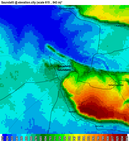
Below is the Elevation map of Saundatti, which displays elevation range with different colors. Scale of the first map is from 615 to 843 m (2018 to 2766 ft) with average elevation of 673.1 meters (=2208 ft) [note 1]
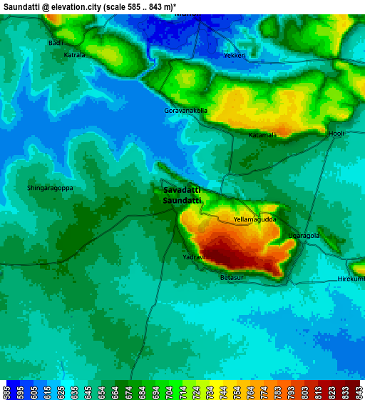
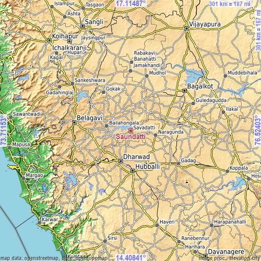
These maps also provides idea of topography and contour of this city, they are displayed at different zoom levels. More info about maps, scale and edge coordinates you can find below images.
| \ | Map #1 | Map #2 | Topo.Map |
| Scale [m] | 615..843 m | 585..843 m | × |
| Scale [ft] | 2018..2766 ft | 1919..2766 ft | × |
| Average | 673.1 m = 2208 ft | 655.7 m = 2151 ft | × |
| Width | 9.4 km = 5.8 mi | 18.81 km = 11.7 mi | 300.9 km = 187 mi |
| Height | 9.4 km = 5.8 mi | 18.81 km = 11.7 mi | 301 km = 187 mi |
| ↑Max Latitude | 15.808438° | 15.850716° | 17.11487° |
| Latitude at center | 15.76615° | 15.76615° | 15.76615° |
| ↓Min Latitude | 15.723854° | 15.681548° | 14.40841° |
| ← Min Longitude | 75.073835° | 75.029889° | 73.71153° |
| Longitude center | 75.11778° | 75.11778° | 75.11778° |
| →Max Longitude | 75.161725° | 75.205671° | 76.52403° |
Nearby cities:
Cities around Saundatti sort by population:
• Hubli elevation 620 m
46.6 km,  177°
177°
• Gokak 555 m
54.7 km,  324°
324°
• Bail-Hongal 687 m
28.2 km,  280°
280°
• Nargund 606 m
29.2 km,  99°
99°
• Bādāmi 560 m
62 km,  74°
74°
• Annigeri 631 m
50.8 km,  138°
138°
• Navalgund 585 m
34.1 km,  132°
132°
• Haliyal 554 m
62.2 km,  218°
218°
• Konnūr 622 m
62.4 km, 320°
• Kerūr 629 m
53.5 km,  58°
58°
• Kundgol 645 m
58.4 km,  166°
166°
• Alnāvar 576 m
55.2 km,  226°
226°
Multilingual:
 En español:
Saundatti elevación 660 m.
 En France:
Saundatti élévation 660 m.
 Auf Deutsch:
Saundatti höhe über dem Meeresspiegel ist 660 m.

Sources and notes:
- [note 1] Map square and city borders are not equal. Map elevation data is calculated only from area inside that square.
- [src 1] Elevation data from geonames database provided with same terms of usage.
- [src 2] The elevation map of Saundatti is generated using elevation data from NASA's 3 arcsec (90m) resolution SRTM data.
- [src 3] Base (background) map © OpenStreetMap contributors tiles are generated by Geofabrik and OpenTopoMap.
Copyright & License:
This Saundatti Elevation Map is licensed under CC BY-SA. You may reuse any part from this page, if you give a proper credit by linking to this URL:
 More info on terms of use page.